
Make a donation
Gear up for your next adventure:
As an Amazon Associate, this site earns from qualifying purchases at no extra cost to you.
Kaktovik topographic map
Click on the map to display elevation.
Make a donation
Gear up for your next adventure:
As an Amazon Associate, this site earns from qualifying purchases at no extra cost to you.
About this map
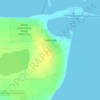
Name: Kaktovik topographic map, elevation, terrain.
Location: Kaktovik, North Slope, Alaska, 99747, United States (70.11676 -143.65781 70.13290 -143.59457)
Average elevation: 16 ft
Minimum elevation: 0 ft
Maximum elevation: 66 ft
North Slope trails, hiking, mountain biking, running and outdoor activities
Make a donation
Gear up for your next adventure:
As an Amazon Associate, this site earns from qualifying purchases at no extra cost to you.
Other topographic maps
Click on a map to view its topography, its elevation and its terrain.
Deadhorse
United States > Alaska > North Slope
In February 2023, a "high altitude object" about the size of a small car was shot down near the area after a decision by President Joe Biden.
Average elevation: 49 ft
Make a donation
Gear up for your next adventure:
As an Amazon Associate, this site earns from qualifying purchases at no extra cost to you.