
Make a donation
Gear up for your next adventure:
As an Amazon Associate, this site earns from qualifying purchases at no extra cost to you.
Changchun City topographic map
Click on the map to display elevation.
Make a donation
Gear up for your next adventure:
As an Amazon Associate, this site earns from qualifying purchases at no extra cost to you.
Changchun City
Changchun lies in the middle portion of the Northeast China Plain. Its municipality area is located at latitude 43° 05′−45° 15′ N and longitude 124° 18′−127° 02' E. The total area of Changchun municipality is 20,571 km2 (7,943 sq mi), including metro areas of 2,583 square kilometres (997 sq mi), and a city proper area of 159 km2 (61 sq mi). The city is situated at a moderate elevation, ranging from 250 to 350 metres (820 to 1,150 ft) within its administrative region. In the eastern portion of the city, there lies a small area of low mountains, with the Laodaodong Mountain, which has an altitude of 711 meters, being the highest. The city is also situated at the crisscross point of the third east–westward "Europe-Asia Continental Bridge". Changchun prefecture is dotted with 222 rivers and lakes. The Yitong River, a small tributary of the Songhua River, runs through the city proper.
Make a donation
Gear up for your next adventure:
As an Amazon Associate, this site earns from qualifying purchases at no extra cost to you.
About this map
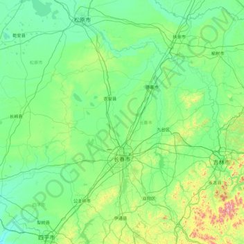
Name: Changchun City topographic map, elevation, terrain.
Location: Changchun City, Jilin, Chinese mainland, 130000, China (43.15999 124.00874 45.25134 127.08779)
Average elevation: 705 ft
Minimum elevation: 331 ft
Maximum elevation: 4,426 ft
Make a donation
Gear up for your next adventure:
As an Amazon Associate, this site earns from qualifying purchases at no extra cost to you.
Other topographic maps
Click on a map to view its topography, its elevation and its terrain.
Make a donation
Gear up for your next adventure:
As an Amazon Associate, this site earns from qualifying purchases at no extra cost to you.
Make a donation
Gear up for your next adventure:
As an Amazon Associate, this site earns from qualifying purchases at no extra cost to you.
Make a donation
Gear up for your next adventure:
As an Amazon Associate, this site earns from qualifying purchases at no extra cost to you.
Make a donation
Gear up for your next adventure:
As an Amazon Associate, this site earns from qualifying purchases at no extra cost to you.
Make a donation
Gear up for your next adventure:
As an Amazon Associate, this site earns from qualifying purchases at no extra cost to you.