Geolocate

Cedarville topographic map

Click on the map to display elevation.

About this map

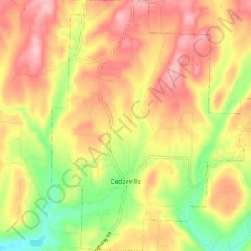
Name: Cedarville topographic map, elevation, terrain.

Location: Cedarville, Crawford County, Arkansas, 72932, United States (35.55363 -94.38809 35.61191 -94.32006)

Average elevation: 915 ft

Minimum elevation: 620 ft

Maximum elevation: 1,148 ft

Crawford County trails, hiking, mountain biking, running and outdoor activities

Other topographic maps

Click on a map to view its topography, its elevation and its terrain.

Artist Point

United States > Arkansas > Crawford County

Average elevation: 1,467 ft

Barcelona

United States > Arkansas > Crawford County

Average elevation: 774 ft

Uniontown

United States > Arkansas > Crawford County

Average elevation: 850 ft

Dora

United States > Arkansas > Crawford County

Average elevation: 531 ft

Alma

United States > Arkansas > Crawford County

Average elevation: 554 ft

Lee Creek

United States > Arkansas > Crawford County

Average elevation: 928 ft

Dyer

United States > Arkansas > Crawford County

Average elevation: 459 ft

Gear up for your next adventure:

📡Handheld GPS Device - Reliable handheld GPS for outdoor navigation
🔥Plasma Lighters - Windproof lighters that work in any weather condition
📱Solar Portable Charger - Solar power bank for charging devices off‑grid
🔭Stargazing Telescopes - Perfect for camping in low-light pollution areas shown on maps
📚USA Hiking Guide Books - Top trail guides and map books

As an Amazon Associate, this site earns from qualifying purchases at no extra cost to you.