Geolocate

Dyer topographic map

Click on the map to display elevation.

About this map

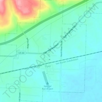
Name: Dyer topographic map, elevation, terrain.

Location: Dyer, Crawford County, Arkansas, 72935, United States (35.47926 -94.15782 35.51180 -94.12304)

Average elevation: 459 ft

Minimum elevation: 367 ft

Maximum elevation: 807 ft

Crawford County trails, hiking, mountain biking, running and outdoor activities

Other topographic maps

Click on a map to view its topography, its elevation and its terrain.

Van Buren

United States > Arkansas > Crawford County

Average elevation: 482 ft

Artist Point

United States > Arkansas > Crawford County

Average elevation: 1,467 ft

Barcelona

United States > Arkansas > Crawford County

Average elevation: 774 ft

Uniontown

United States > Arkansas > Crawford County

Average elevation: 850 ft

Dora

United States > Arkansas > Crawford County

Average elevation: 531 ft

Rudy

United States > Arkansas > Crawford County

Average elevation: 643 ft

Chester

United States > Arkansas > Crawford County

Average elevation: 1,027 ft

Kibler

United States > Arkansas > Crawford County

Average elevation: 440 ft

Cedarville

United States > Arkansas > Crawford County

Average elevation: 915 ft

Lee Creek

United States > Arkansas > Crawford County

Average elevation: 928 ft

Mulberry

United States > Arkansas > Crawford County

Average elevation: 436 ft

Gear up for your next adventure:

💧Water Filtration Bottles - Safely drink from streams and lakes while exploring
📌Outdoor GPS Map App - Apps and devices for digital topographic navigation
🧤Tactile Hiking Gloves - Keep hands warm while operating GPS and smartphone screens
🌡️Handheld Weather Meters - Measure wind, temp, and pressure for safe mountain travel
🔦Compact Flashlight - Reliable flashlight for emergencies

As an Amazon Associate, this site earns from qualifying purchases at no extra cost to you.