Geolocate

Uniontown topographic map

Click on the map to display elevation.

About this map

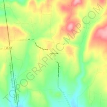
Name: Uniontown topographic map, elevation, terrain.

Location: Uniontown, Crawford County, Arkansas, 72955, United States (35.56453 -94.46410 35.60453 -94.42410)

Average elevation: 850 ft

Minimum elevation: 630 ft

Maximum elevation: 1,096 ft

Crawford County trails, hiking, mountain biking, running and outdoor activities

Other topographic maps

Click on a map to view its topography, its elevation and its terrain.

Van Buren

United States > Arkansas > Crawford County

Average elevation: 482 ft

Rudy

United States > Arkansas > Crawford County

Average elevation: 643 ft

Chester

United States > Arkansas > Crawford County

Average elevation: 1,027 ft

Kibler

United States > Arkansas > Crawford County

Average elevation: 440 ft

Cedarville

United States > Arkansas > Crawford County

Average elevation: 915 ft

Alma

United States > Arkansas > Crawford County

Average elevation: 554 ft

Mulberry

United States > Arkansas > Crawford County

Average elevation: 436 ft

Dyer

United States > Arkansas > Crawford County

Average elevation: 459 ft

Gear up for your next adventure:

🎒Gear Packing Cubes - Organize your backpack efficiently
🎒Trekking Poles - Sturdy poles for balance and stability on rough terrain
🦺Reflective Outdoor Gear - Safety gear for low‑light conditions
🥾Hiking Shoes - Durable and comfortable shoes for trail hiking
🔋Rechargeable Batteries - Power up your outdoor devices

As an Amazon Associate, this site earns from qualifying purchases at no extra cost to you.