
Galicia topographic map
Interactive map
Click on the map to display elevation.
About this map
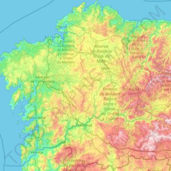
Name: Galicia topographic map, elevation, terrain.
Location: Galicia, Spain (41.80736 -9.30154 43.79042 -6.73395)
Average elevation: 1,496 ft
Minimum elevation: -7 ft
Maximum elevation: 6,850 ft
The interior of Galicia is characterized by a hilly landscape; mountain ranges rise to 2,000 m (6,600 ft) in the east and south. The coastal areas are mostly an alternate series of rias and beaches. The climate of Galicia is usually temperate and rainy, with markedly drier summers; it is usually classified as Oceanic. Its topographic and climatic conditions have made animal husbandry and farming the primary source of Galicia's wealth for most of its history, allowing for a relatively high density of population. Except shipbuilding and food processing, Galicia was based on a farming and fishing economy until after the mid-20th century, when it began to industrialize. In 2018, the nominal gross domestic product was €62.900 billion, with a nominal GDP per capita of €23,300. Galicia is characterised, unlike other Spanish regions, by the absence of a metropolis dominating the territory. Indeed, the urban network is made up of 7 main cities (the four provincial capitals A Coruña, Pontevedra, Ourense and Lugo, the political capital Santiago de Compostela and the industrial cities Vigo and Ferrol and other small towns. The population is largely concentrated in two main areas: from Ferrol to A Coruña on the northern coast, and in the Rías Baixas region in the southwest, including the cities of Vigo, Pontevedra, and the interior city of Santiago de Compostela. There are smaller populations around the interior cities of Lugo and Ourense. The political capital is Santiago de Compostela, in the province of A Coruña. Vigo, in the province of Pontevedra, is the largest municipality in Galicia and also the most populated city. Two languages are official and widely used today in Galicia: the native Galician, a Romance language closely related to Portuguese with which it shares the Galician-Portuguese medieval literature; and Spanish, usually called Castilian. While most Galicians are bilingual, a 2013 survey reported that 51% of the Galician population spoke Galician most often on a day-to-day basis, while 48% most often used Spanish.
Other topographic maps
Click on a map to view its topography, its elevation and its terrain.
Málaga
Spain > Andalusia > Málaga-Costa del Sol
Málaga, Málaga-Costa del Sol, Malaga, Andalusia, Spain
Average elevation: 906 ft
Barcelona
Spain > Catalonia > Barcelonès
Barcelona, Barcelonès, Barcelona, Catalonia, 08001, Spain
Average elevation: 213 ft
la Coma
Spain > Catalonia > Solsonès > la Coma i la Pedra
la Coma, la Coma i la Pedra, Solsonès, Lleida, Catalonia, 25284, Spain
Average elevation: 4,291 ft
Benifato
Benifato, la Marina Baixa, Alacant / Alicante, Valencian Community, Spain
Average elevation: 3,081 ft
Barbadillo de Herreros
Barbadillo de Herreros, Burgos, Castile and León, 09615, Spain
Average elevation: 4,751 ft
Santa Cruz de la Zarza
Santa Cruz de la Zarza, Toledo, Castile-La Mancha, 45370, Spain
Average elevation: 2,375 ft
Blanca
Spain > Castile and León > Riello
Blanca, Riello, León, Castile and León, 24127, Spain
Average elevation: 3,914 ft
Granada
Spain > Andalusia > Comarca de la Vega de Granada
Granada, Comarca de la Vega de Granada, Granada, Andalusia, Spain
Average elevation: 2,720 ft
La Unión de los Tres Ejércitos
La Unión de los Tres Ejércitos, Clavijo, Rioja, 26141, Spain
Average elevation: 2,133 ft
Tellego
Spain > Asturias > Ribera de Arriba > Soto Ribera
Tellego, Soto Ribera, Ribera de Arriba, Asturias, 33173, Spain
Average elevation: 843 ft
Vinaròs
Vinaròs, el Baix Maestrat, Castelló / Castellón, Valencian Community, 12500, Spain
Average elevation: 177 ft
Gobernador
Spain > Andalusia > Comarca de Los Montes
Gobernador, Comarca de Los Montes, Granada, Andalusia, 18563, Spain
Average elevation: 3,576 ft
Siurana
Spain > Catalonia > Upper Empordà
Siurana, Upper Empordà, Girona, Catalonia, 17469, Spain
Average elevation: 102 ft
Ronda
Spain > Andalusia > Serranía de Ronda
Ronda, Serranía de Ronda, Malaga, Andalusia, Spain
Average elevation: 2,628 ft
Son Servera
Spain > Balearic Islands > Llevant
Son Servera, Llevant, Balearic Islands, Spain
Average elevation: 308 ft
Villar del Arzobispo
Spain > Valencian Community > La Serranía
Villar del Arzobispo, La Serranía, Valencia, Valencian Community, 46170, Spain
Average elevation: 1,562 ft
Fuentespalda
Spain > Aragon > Matarraña / Matarranya
Fuentespalda, Matarraña / Matarranya, Teruel, Aragon, 44587, Spain
Average elevation: 2,333 ft
Alicante
Alicante, l'Alacantí, Alacant / Alicante, Valencian Community, Spain
Average elevation: 469 ft
Castillo de Almodóvar del Río
Spain > Andalusia > Almodóvar del Río
Castillo de Almodóvar del Río, Calle Parvas, Almodóvar del Río, Córdoba, Andalusia, 14720, Spain
Average elevation: 335 ft
Reigada
Spain > Galicia > Terra de Lemos > Monforte de Lemos
Reigada, Monforte de Lemos, Terra de Lemos, Lugo, Galicia, 27411, Spain
Average elevation: 1,102 ft
Sant Andreu
Spain > Catalonia > Barcelonès > Barcelona
Sant Andreu, Barcelona, Barcelonès, Barcelona, Catalonia, 08001, Spain
Average elevation: 184 ft
Oiartzabal
Spain > Iruñerria / Comarca de Pamplona > Anue
Oiartzabal, Anue, Iruñerria / Comarca de Pamplona, Spain
Average elevation: 2,740 ft
Campillos
Spain > Andalusia > Guadalteba
Campillos, Guadalteba, Malaga, Andalusia, 29320, Spain
Average elevation: 1,562 ft
Arriondas / Les Arriondes
Arriondas / Les Arriondes, Parres, Asturias, 33540, Spain
Average elevation: 614 ft
Los Laganes
Spain > Andalusia > La Janda > Alcalá de los Gazules
Los Laganes, Alcalá de los Gazules, La Janda, Cádiz, Andalusia, Spain
Average elevation: 768 ft
Urbanización Palacio de Meres - Fontemera
Urbanización Palacio de Meres - Fontemera, Siero, Asturias, 33199, Spain
Average elevation: 682 ft