
Make a donation
Gear up for your next adventure:
As an Amazon Associate, this site earns from qualifying purchases at no extra cost to you.
Woodcliff Lake topographic map
Click on the map to display elevation.
Make a donation
Gear up for your next adventure:
As an Amazon Associate, this site earns from qualifying purchases at no extra cost to you.
About this map
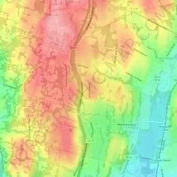
Name: Woodcliff Lake topographic map, elevation, terrain.
Average elevation: 276 ft
Minimum elevation: 56 ft
Maximum elevation: 449 ft
Bergen County trails, hiking, mountain biking, running and outdoor activities
Make a donation
Gear up for your next adventure:
As an Amazon Associate, this site earns from qualifying purchases at no extra cost to you.
Other topographic maps
Click on a map to view its topography, its elevation and its terrain.
Make a donation
Gear up for your next adventure:
As an Amazon Associate, this site earns from qualifying purchases at no extra cost to you.
River Edge
United States > New Jersey > Bergen County > River Edge > River Edge
Average elevation: 69 ft
Make a donation
Gear up for your next adventure:
As an Amazon Associate, this site earns from qualifying purchases at no extra cost to you.
Make a donation
Gear up for your next adventure:
As an Amazon Associate, this site earns from qualifying purchases at no extra cost to you.
New Bridge
United States > New Jersey > Bergen County > New Milford > New Bridge
Average elevation: 62 ft
Wallington
United States > New Jersey > Bergen County > Wallington > Wallington
Average elevation: 75 ft
Warren Point
United States > New Jersey > Bergen County > Fair Lawn > Warren Point
Average elevation: 72 ft
Make a donation
Gear up for your next adventure:
As an Amazon Associate, this site earns from qualifying purchases at no extra cost to you.
Ridgefield
United States > New Jersey > Bergen County > Ridgefield > Ridgefield
Average elevation: 79 ft
Make a donation
Gear up for your next adventure:
As an Amazon Associate, this site earns from qualifying purchases at no extra cost to you.