Geolocate

Much Wenlock topographic map

Click on the map to display elevation.

About this map

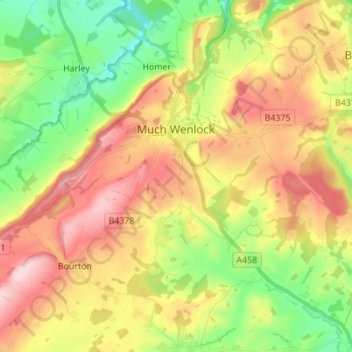
Name: Much Wenlock topographic map, elevation, terrain.

Location: Much Wenlock, Shropshire, England, United Kingdom (52.54248 -2.63677 52.62619 -2.50925)

Average elevation: 522 ft

Minimum elevation: 177 ft

Maximum elevation: 915 ft

Other topographic maps

Click on a map to view its topography, its elevation and its terrain.

Fitz

United Kingdom > England > Shropshire

Average elevation: 243 ft

Aston Munslow

United Kingdom > England > Shropshire

Average elevation: 551 ft

Onston

United Kingdom > England > Shropshire > Tetchill

Average elevation: 315 ft

Selattyn

United Kingdom > England > Shropshire

Average elevation: 794 ft

Alveley

United Kingdom > England > Shropshire

Average elevation: 335 ft

Chirbury

United Kingdom > England > Shropshire

Average elevation: 410 ft

Wem

United Kingdom > England > Shropshire

Average elevation: 289 ft

Oldbury

United Kingdom > England > Shropshire > Bridgnorth

Average elevation: 262 ft

Homer

United Kingdom > England > Shropshire > Much Wenlock

Average elevation: 427 ft

Walford

United Kingdom > England > Shropshire

Average elevation: 272 ft

Ashford Carbonell

United Kingdom > England > Shropshire

Average elevation: 285 ft

Cedars of Lebanon

United Kingdom > England > Shropshire > Atcham

Average elevation: 171 ft

Gear up for your next adventure:

🎒Gear Packing Cubes - Organize your backpack efficiently
🛏️Cold Weather Sleeping Bag - Warm sleeping bag for cold conditions
📡Handheld GPS Device - Reliable handheld GPS for outdoor navigation
🧭Outdoor Navigation Book - Learn advanced navigation skills
🔪Outdoor Multitools - Essential survival tools for gear repair and field use

As an Amazon Associate, this site earns from qualifying purchases at no extra cost to you.