Geolocate

Wem topographic map

Click on the map to display elevation.

About this map

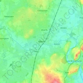
Name: Wem topographic map, elevation, terrain.

Location: Wem, Shropshire, England, SY4 5DG, United Kingdom (52.81563 -2.76412 52.89563 -2.68412)

Average elevation: 289 ft

Minimum elevation: 213 ft

Maximum elevation: 515 ft

Other topographic maps

Click on a map to view its topography, its elevation and its terrain.

Aston Botterell

United Kingdom > England > Shropshire

Average elevation: 666 ft

Church Stretton

United Kingdom > England > Shropshire

Average elevation: 919 ft

Broseley

United Kingdom > England > Shropshire

Average elevation: 466 ft

Much Wenlock

United Kingdom > England > Shropshire

Average elevation: 522 ft

Romsley

United Kingdom > England > Shropshire

Average elevation: 440 ft

Cedars of Lebanon

United Kingdom > England > Shropshire > Atcham

Average elevation: 171 ft

Gear up for your next adventure:

🪵Folding Camp Saw - Compact saw for wood and campsite work
🏕️Family Camping Gear - Essentials for group camping trips
🏥Hiking First Aid Kits - Comprehensive medical kits for remote trail injuries
🧭Compass with Lanyard - Easy‑carry compass for navigation
🖼️Topo Map Wall Art - Decorative topographic prints of famous peaks and regions

As an Amazon Associate, this site earns from qualifying purchases at no extra cost to you.