Geolocate

Millsap topographic map

Click on the map to display elevation.

About this map

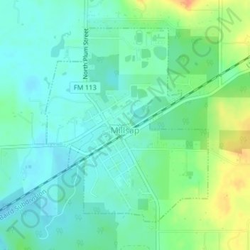
Name: Millsap topographic map, elevation, terrain.

Location: Millsap, Parker County, Texas, United States (32.73825 -98.01942 32.75921 -97.99852)

Average elevation: 843 ft

Minimum elevation: 801 ft

Maximum elevation: 935 ft

Parker County trails, hiking, mountain biking, running and outdoor activities

Other topographic maps

Click on a map to view its topography, its elevation and its terrain.

Poolville

United States > Texas > Parker County

Average elevation: 1,175 ft

Sabathany

United States > Texas > Parker County

Average elevation: 860 ft

Peaster

United States > Texas > Parker County

Average elevation: 1,204 ft

Snake Forest

United States > Texas > Parker County

Average elevation: 1,024 ft

Whitt

United States > Texas > Parker County

Average elevation: 1,112 ft

Authon

United States > Texas > Parker County

Average elevation: 1,043 ft

Slipdown Mountain

United States > Texas > Parker County

Average elevation: 1,280 ft

Brock

United States > Texas > Parker County

Average elevation: 866 ft

Dennis

United States > Texas > Parker County

Average elevation: 764 ft

Agnes

United States > Texas > Parker County

Average elevation: 1,152 ft

Garner

United States > Texas > Parker County

Average elevation: 971 ft

Reno

United States > Texas > Parker County > Reno > Reno

Average elevation: 741 ft

Gear up for your next adventure:

🌄Hiking Binoculars - Compact binoculars for scenic views and trail spotting
🦶Carbon Trekking Poles - Reduce knee impact on steep descents with ultra-light poles
☀️Outdoor Sunscreen - High protection sunscreen for outdoor activities
🏫Relief Map Kits - Hands-on tools for teaching landforms and elevation
GPS Sports Watch - GPS watch for running, hiking and training

As an Amazon Associate, this site earns from qualifying purchases at no extra cost to you.