
Make a donation
Gear up for your next adventure:
As an Amazon Associate, this site earns from qualifying purchases at no extra cost to you.
Buren topographic map
Click on the map to display elevation.
Make a donation
Gear up for your next adventure:
As an Amazon Associate, this site earns from qualifying purchases at no extra cost to you.
About this map
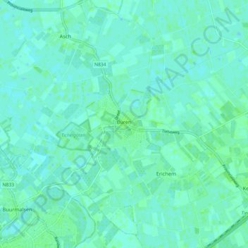
Name: Buren topographic map, elevation, terrain.
Location: Buren, Gelderland, Nederland (51.88962 5.27975 51.93206 5.36958)
Average elevation: 13 ft
Minimum elevation: 3 ft
Maximum elevation: 23 ft
Make a donation
Gear up for your next adventure:
As an Amazon Associate, this site earns from qualifying purchases at no extra cost to you.
Other topographic maps
Click on a map to view its topography, its elevation and its terrain.
Arnhem
Nederland > Gelderland > Arnhem
De stad telt meerdere theaters, waarvan het Stadstheater Arnhem het belangrijkste is. Dit theater doet dienst als schouwburg en als concertzaal. Musis Sacrum op het Velperplein is het vaste concertgebouw van Phion, het orkest van Gelderland en Overijssel. Theater aan de Rijn, KAB Posttheater, Huis van Puck,…
Average elevation: 79 ft
Achterhoek
Nederland > Gelderland > Lievelde
Wie zich een beeld probeert te vormen van het oorspronkelijke landschap, ziet een woest en moeilijk toegankelijk gebied. Het gebied bestaat uit dekzandruggen, uitlopers van een diluviaal hoogteterras van oostelijke zijde. Vele beken stromen van oost naar west en voedden een lager gelegen strook van moerasbos…
Average elevation: 177 ft
Flierenberg
Nederland > Gelderland > Berg en Dal
De Nederrijnse Heuvelrug (Duits: Niederrheinischer Höhenzug) is een stuwwal, die zich met verschillende onderbrekingen in het westen van het Nederrijnse Laagvlakte van Krefeld tot Nijmegen in een wijde boog tussen het Rijndal in het oosten en het dal van de Niers uitstrekt. Dit landschapelement wordt ook wel…
Average elevation: 236 ft
Make a donation
Gear up for your next adventure:
As an Amazon Associate, this site earns from qualifying purchases at no extra cost to you.
Wageningen-Hoog
Nederland > Gelderland > Wageningen
Wageningen-Hoog ligt in een bosrijke omgeving op de Zuidwest-Veluwe op een stuwwal op hoogten tussen 30 en 50 meter boven NAP. Het terrein loopt omhoog vanuit het zuidwesten naar een hoogste punt van circa 50 meter in het noordoosten. De stad Wageningen ligt lager, aan de Rijn. De plaats is opgezet met huizen…
Average elevation: 89 ft
Make a donation
Gear up for your next adventure:
As an Amazon Associate, this site earns from qualifying purchases at no extra cost to you.
Make a donation
Gear up for your next adventure:
As an Amazon Associate, this site earns from qualifying purchases at no extra cost to you.
Make a donation
Gear up for your next adventure:
As an Amazon Associate, this site earns from qualifying purchases at no extra cost to you.
Make a donation
Gear up for your next adventure:
As an Amazon Associate, this site earns from qualifying purchases at no extra cost to you.
Make a donation
Gear up for your next adventure:
As an Amazon Associate, this site earns from qualifying purchases at no extra cost to you.
Meulunteren
Nederland > Gelderland > Lunteren
Het ligt aan de Meulunterseweg die van Lunteren naar De Valk loopt, ongeveer ter hoogte van de kruising met de Hessenweg aan de voet van de Goudsberg.
Average elevation: 66 ft
Make a donation
Gear up for your next adventure:
As an Amazon Associate, this site earns from qualifying purchases at no extra cost to you.
Make a donation
Gear up for your next adventure:
As an Amazon Associate, this site earns from qualifying purchases at no extra cost to you.
Make a donation
Gear up for your next adventure:
As an Amazon Associate, this site earns from qualifying purchases at no extra cost to you.
Make a donation
Gear up for your next adventure:
As an Amazon Associate, this site earns from qualifying purchases at no extra cost to you.
Signaal Imbosch
Nederland > Gelderland > Rheden
Signaal Imbosch is een heuvel van 109,9 meter hoogte (volgens de Rijksdriehoeksmeting) in de gemeente Rheden in het Nationaal Park Veluwezoom. Het is het hoogste punt van de Veluwe, van de provincie Gelderland en tevens het hoogste punt van het Europese deel van Nederland buiten Zuid-Limburg.
Average elevation: 282 ft
Make a donation
Gear up for your next adventure:
As an Amazon Associate, this site earns from qualifying purchases at no extra cost to you.
Miste
Nederland > Gelderland > Winterswijk Miste
Ten zuiden van Miste loopt de spoorlijn Winterswijk - Zevenaar die eind 19e eeuw is gerealiseerd en door de GOLS werd geëxploiteerd. Ter hoogte van Miste, bij de Halteweg, was er een spoorweghalte voor bewoners uit Miste, te weten halte Miste. Deze is in 1933 gesloten.
Average elevation: 102 ft
Make a donation
Gear up for your next adventure:
As an Amazon Associate, this site earns from qualifying purchases at no extra cost to you.
Make a donation
Gear up for your next adventure:
As an Amazon Associate, this site earns from qualifying purchases at no extra cost to you.
Make a donation
Gear up for your next adventure:
As an Amazon Associate, this site earns from qualifying purchases at no extra cost to you.
Alverna
Nederland > Gelderland > Wijchen
Dit franciscanenklooster werd tussen 1886 en 1889 gebouwd aan de provinciale weg tussen Nijmegen en Grave ter hoogte van Wijchen. Rondom dit klooster ontstond gaandeweg een buurtschap met een eigen parochie, een eigen voetbalclub en zelfs een eigen poststempel en vertegenwoordiging in de gemeenteraad van…
Average elevation: 33 ft
Make a donation
Gear up for your next adventure:
As an Amazon Associate, this site earns from qualifying purchases at no extra cost to you.
Make a donation
Gear up for your next adventure:
As an Amazon Associate, this site earns from qualifying purchases at no extra cost to you.
Make a donation
Gear up for your next adventure:
As an Amazon Associate, this site earns from qualifying purchases at no extra cost to you.
Make a donation
Gear up for your next adventure:
As an Amazon Associate, this site earns from qualifying purchases at no extra cost to you.
Make a donation
Gear up for your next adventure:
As an Amazon Associate, this site earns from qualifying purchases at no extra cost to you.
Make a donation
Gear up for your next adventure:
As an Amazon Associate, this site earns from qualifying purchases at no extra cost to you.
Make a donation
Gear up for your next adventure:
As an Amazon Associate, this site earns from qualifying purchases at no extra cost to you.
Oosterhuizen
Nederland > Gelderland > Lieren
Zo kon het gebeuren dat op de avond van 16 april 1945 er een paar Canadese soldaten in Oosterhuizen poolshoogte kwamen nemen, voordat de rest het kanaal zou oversteken. Zij vormden een verkenningspatrouille, die was uitgestuurd door de PPCLI. In de vroege morgen van 17 april had de genie de vernielde brug door…
Average elevation: 62 ft
Make a donation
Gear up for your next adventure:
As an Amazon Associate, this site earns from qualifying purchases at no extra cost to you.
Make a donation
Gear up for your next adventure:
As an Amazon Associate, this site earns from qualifying purchases at no extra cost to you.
Sonsbeek
Nederland > Gelderland > Arnhem
Park Angerenstein · Bronbeek · Gulden Bodem · Hoogte 80 · Immerloopark · Jubileumpark · Park Klarenbeek · Lichtenbeek en Boschveld · Mariëndaal · Stadsblokken-Meinerswijk · Moscowa · Onderlangs · Park Presikhaaf · Park Sonsbeek · Warnsborn · Westerheide · Park Westerveld · Park Zypendaal
Average elevation: 141 ft
Make a donation
Gear up for your next adventure:
As an Amazon Associate, this site earns from qualifying purchases at no extra cost to you.
Make a donation
Gear up for your next adventure:
As an Amazon Associate, this site earns from qualifying purchases at no extra cost to you.