
Llaylla topographic map
Click on the map to display elevation.
About this map
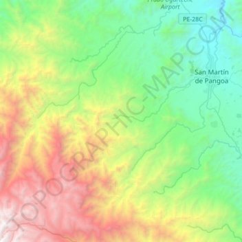
Name: Llaylla topographic map, elevation, terrain.
Location: Llaylla, Province of Satipo, Junín, Peru (-11.61199 -74.76601 -11.34464 -74.52806)
Average elevation: 5,945 ft
Minimum elevation: 1,883 ft
Maximum elevation: 14,219 ft
Other topographic maps
Click on a map to view its topography, its elevation and its terrain.
Huancayo
Huancayo (Spanish pronunciation: [waŋˈkaʝo]; in Wanka Quechua: Wankayu, '(place) with a (sacred) rock', Quechua pronunciation: [waŋˈkajuː]) is the capital of the Junín Region and Huancayo Province, in the central highlands of Peru, in the Mantaro Valley and is crossed by the Shullcas, Chilca and Mantaro…
Average elevation: 12,526 ft