
Make a donation
Gear up for your next adventure:
As an Amazon Associate, this site earns from qualifying purchases at no extra cost to you.
Limerick topographic map
Click on the map to display elevation.
Make a donation
Gear up for your next adventure:
As an Amazon Associate, this site earns from qualifying purchases at no extra cost to you.
Limerick
Limerick's climate is classified as temperate oceanic (Köppen Cfb). Met Éireann maintains a climatological weather station at Shannon Airport, 20 kilometres west of the city in County Clare. Shannon Airport records an average of 977 millimetres of precipitation annually, most of which is rain. Limerick has a mild climate, with the average daily maximum in July of 20 °C (68 °F) and the average daily minimum in January of 3 °C (37 °F). The highest temperature recorded was 32.0 °C (89.6 °F) in June 2018, and the lowest −11.4 °C (11.5 °F) in 2010. Limerick is the cloudiest city in the country, averaging only 1,295 sunshine hours annually, 3.5 hours of sunshine every day. There are on average 62 days of no recordable sunshine, 6 days of thunder, 22 days of hail and 11 days of snow per year. Shannon Airport is located by the ocean at an elevation of 14 metres, so snow is less common at the station than in the city itself.
Make a donation
Gear up for your next adventure:
As an Amazon Associate, this site earns from qualifying purchases at no extra cost to you.
About this map
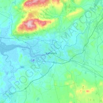
Name: Limerick topographic map, elevation, terrain.
Location: Limerick, County Limerick, Munster, Ireland (52.57210 -8.80708 52.75738 -8.44254)
Average elevation: 148 ft
Minimum elevation: -85 ft
Maximum elevation: 994 ft
Make a donation
Gear up for your next adventure:
As an Amazon Associate, this site earns from qualifying purchases at no extra cost to you.
Other topographic maps
Click on a map to view its topography, its elevation and its terrain.
Kilcruaig
Ireland > County Limerick > The Municipal District of Cappamore — Kilmallock
Average elevation: 656 ft
Knockadea
Ireland > County Limerick > The Municipal District of Cappamore — Kilmallock
Average elevation: 666 ft
Pallasgreen
Ireland > County Limerick > The Municipal District of Cappamore — Kilmallock
Average elevation: 236 ft
Galtymore
Ireland > County Limerick > The Municipal District of Cappamore — Kilmallock
Galtymore or Galteemore (Irish: Cnoc Mór na nGaibhlte, meaning 'big hill of the Galtees') is a mountain in the province of Munster, Ireland. At 917.9 metres (3,011 ft 6 in), it is one of Ireland's highest mountains, being the 12th-highest on the Arderin list, and 14th-highest on the Vandeleur-Lynam list.…
Average elevation: 1,949 ft
Make a donation
Gear up for your next adventure:
As an Amazon Associate, this site earns from qualifying purchases at no extra cost to you.
Aherlow
Ireland > County Limerick > The Municipal District of Cappamore — Kilmallock
Average elevation: 463 ft
Limerick
Ireland > County Limerick > Limerick
Limerick's climate is classified as temperate oceanic (Köppen Cfb). Met Éireann maintains a climatological weather station at Shannon Airport, 20 kilometres west of the city in County Clare. Shannon Airport records an average of 977 millimetres of precipitation annually, most of which is rain. Limerick has a…
Average elevation: 33 ft
Clare Glens
Ireland > County Limerick > The Municipal District of Cappamore — Kilmallock
Average elevation: 407 ft
Make a donation
Gear up for your next adventure:
As an Amazon Associate, this site earns from qualifying purchases at no extra cost to you.
Knockawarriga
Ireland > County Limerick > The Municipal District of Newcastle West
Average elevation: 810 ft
Crecora
Ireland > County Limerick > The Municipal District of Adare — Rathkeale
Average elevation: 121 ft
Bleach Lough
Ireland > County Limerick > The Municipal District of Adare — Rathkeale
Average elevation: 33 ft
Ardpatrick
Ireland > County Limerick > The Municipal District of Cappamore — Kilmallock
Average elevation: 554 ft
Make a donation
Gear up for your next adventure:
As an Amazon Associate, this site earns from qualifying purchases at no extra cost to you.
Templeglantine
Ireland > County Limerick > The Municipal District of Newcastle West
Average elevation: 620 ft
Bruff
Ireland > County Limerick > The Municipal District of Cappamore — Kilmallock
Average elevation: 223 ft
Make a donation
Gear up for your next adventure:
As an Amazon Associate, this site earns from qualifying purchases at no extra cost to you.
Bruree
Ireland > County Limerick > The Municipal District of Cappamore — Kilmallock
Average elevation: 203 ft
Croom
Ireland > County Limerick > The Municipal District of Adare — Rathkeale > Croom
Average elevation: 112 ft
Make a donation
Gear up for your next adventure:
As an Amazon Associate, this site earns from qualifying purchases at no extra cost to you.
Tory Hill
Ireland > County Limerick > The Municipal District of Adare — Rathkeale
Average elevation: 115 ft
Make a donation
Gear up for your next adventure:
As an Amazon Associate, this site earns from qualifying purchases at no extra cost to you.