
Make a donation
Gear up for your next adventure:
As an Amazon Associate, this site earns from qualifying purchases at no extra cost to you.
Sutton No. 103 topographic map
Click on the map to display elevation.
Make a donation
Gear up for your next adventure:
As an Amazon Associate, this site earns from qualifying purchases at no extra cost to you.
About this map
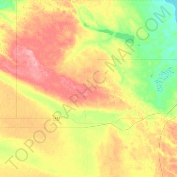
Name: Sutton No. 103 topographic map, elevation, terrain.
Location: Sutton No. 103, Division No 3, Saskatchewan, Canada (49.78540 -106.41455 50.04780 -106.00505)
Average elevation: 2,352 ft
Minimum elevation: 2,182 ft
Maximum elevation: 2,536 ft
Make a donation
Gear up for your next adventure:
As an Amazon Associate, this site earns from qualifying purchases at no extra cost to you.
Other topographic maps
Click on a map to view its topography, its elevation and its terrain.
Pike Lake Provincial Park
Canada > Saskatchewan > Pike Lake Provincial Park
Average elevation: 1,634 ft
Make a donation
Gear up for your next adventure:
As an Amazon Associate, this site earns from qualifying purchases at no extra cost to you.
Beauval
Canada > Saskatchewan > Northern Saskatchewan Administration District > Beauval
Average elevation: 1,424 ft
Make a donation
Gear up for your next adventure:
As an Amazon Associate, this site earns from qualifying purchases at no extra cost to you.