
Khed topographic map
Click on the map to display elevation.
About this map
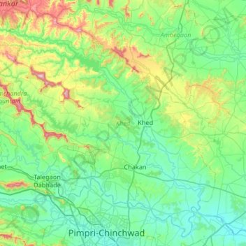
Name: Khed topographic map, elevation, terrain.
Location: Khed, Pune, Maharashtra, India (18.61924 73.51523 19.08284 74.04459)
Average elevation: 2,231 ft
Minimum elevation: 1,768 ft
Maximum elevation: 4,065 ft
Other topographic maps
Click on a map to view its topography, its elevation and its terrain.
Alandi
India > Maharashtra > Khed
Alandi (18°40′37.42″N 73°53′47.76″E / 18.6770611°N 73.8966000°E / 18.6770611; 73.8966000) is located on the bank of the Indrayani River, 18.8 km (11.7 mi) from Khed Taluka of Pune District, near the northern edge of the city of Pune. Alandi has an average elevation of 577 meters (1,893 feet).
Average elevation: 1,896 ft