
Willesley topographic map
Click on the map to display elevation.
About this map
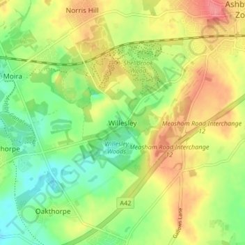
Name: Willesley topographic map, elevation, terrain.
Average elevation: 361 ft
Minimum elevation: 249 ft
Maximum elevation: 489 ft
Other topographic maps
Click on a map to view its topography, its elevation and its terrain.
Ashby-de-la-Zouch
United Kingdom > England > Leicestershire > North West Leicestershire
Average elevation: 433 ft
Kelham Bridge Nature Reserve
United Kingdom > England > Leicestershire > North West Leicestershire > Ravenstone
Average elevation: 456 ft
Castle Donington
United Kingdom > England > Leicestershire > North West Leicestershire > Hemington
Average elevation: 184 ft
Swannington
United Kingdom > England > Leicestershire > North West Leicestershire > Coalville
Average elevation: 433 ft
Lount Wood
United Kingdom > England > Leicestershire > North West Leicestershire > Lount
Average elevation: 430 ft
Measham
United Kingdom > England > Leicestershire > North West Leicestershire
Average elevation: 315 ft
Ibstock
United Kingdom > England > Leicestershire > North West Leicestershire
Average elevation: 440 ft
Whitwick
United Kingdom > England > Leicestershire > North West Leicestershire
Average elevation: 499 ft
Appleby Magna
United Kingdom > England > Leicestershire > North West Leicestershire
Average elevation: 312 ft
Nailstone Colliery Railway
United Kingdom > England > Leicestershire > North West Leicestershire > Ibstock
Average elevation: 509 ft
Sence Valley Country Park
United Kingdom > England > Leicestershire > North West Leicestershire > Heather
Average elevation: 430 ft
Staunton Harold
United Kingdom > England > Leicestershire > North West Leicestershire > Lount
Average elevation: 354 ft
Breedon Cloud Wood
United Kingdom > England > Leicestershire > North West Leicestershire > Breedon on the Hill
Average elevation: 295 ft
Swannymote Rock
United Kingdom > England > Leicestershire > North West Leicestershire > Coalville
Average elevation: 456 ft
Willesley Woods
United Kingdom > England > Leicestershire > North West Leicestershire > Ashby-de-la-Zouch > Willesley
Average elevation: 354 ft
Osgathorpe
United Kingdom > England > Leicestershire > North West Leicestershire
Average elevation: 315 ft
Normanton Le Heath
United Kingdom > England > Leicestershire > North West Leicestershire
Average elevation: 404 ft
Kegworth
United Kingdom > England > Leicestershire > North West Leicestershire > Kegworth
Average elevation: 161 ft
Packington
United Kingdom > England > Leicestershire > North West Leicestershire
Average elevation: 390 ft
Coleorton
United Kingdom > England > Leicestershire > North West Leicestershire
Average elevation: 427 ft
Ashby de la Zouch Canal
United Kingdom > England > Leicestershire > North West Leicestershire > Moira
Average elevation: 328 ft
Worthington
United Kingdom > England > Leicestershire > North West Leicestershire
Average elevation: 338 ft
Isley cum Langley
United Kingdom > England > Leicestershire > North West Leicestershire > Isley Walton
Average elevation: 262 ft
Belton
United Kingdom > England > Leicestershire > North West Leicestershire
Average elevation: 295 ft
Ashby de la Zouch Canal
United Kingdom > England > Leicestershire > North West Leicestershire > Oakthorpe
Average elevation: 318 ft
Cademan Wood
United Kingdom > England > Leicestershire > North West Leicestershire > Whitwick
Average elevation: 453 ft
New Lount Nature Reserve
United Kingdom > England > Leicestershire > North West Leicestershire > Worthington
Average elevation: 394 ft
Whitwick
United Kingdom > England > Leicestershire > North West Leicestershire
Average elevation: 499 ft
Measham
United Kingdom > England > Leicestershire > North West Leicestershire
Average elevation: 318 ft