
Packington topographic map
Click on the map to display elevation.
About this map
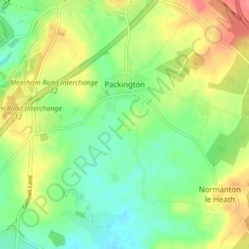
Name: Packington topographic map, elevation, terrain.
Average elevation: 390 ft
Minimum elevation: 302 ft
Maximum elevation: 512 ft
Other topographic maps
Click on a map to view its topography, its elevation and its terrain.
Coalville
United Kingdom > England > Leicestershire > North West Leicestershire
Average elevation: 489 ft
Kelham Bridge Nature Reserve
United Kingdom > England > Leicestershire > North West Leicestershire > Ravenstone
Average elevation: 456 ft
Isley Walton
United Kingdom > England > Leicestershire > North West Leicestershire
Average elevation: 249 ft
Thringstone
United Kingdom > England > Leicestershire > North West Leicestershire
Average elevation: 413 ft
Lount Wood
United Kingdom > England > Leicestershire > North West Leicestershire > Lount
Average elevation: 430 ft
Breedon on the Hill
United Kingdom > England > Leicestershire > North West Leicestershire
Average elevation: 276 ft
Ravenstone
United Kingdom > England > Leicestershire > North West Leicestershire
Average elevation: 469 ft
Nailstone Colliery Railway
United Kingdom > England > Leicestershire > North West Leicestershire > Ibstock
Average elevation: 509 ft
Sence Valley Country Park
United Kingdom > England > Leicestershire > North West Leicestershire > Heather
Average elevation: 430 ft
Long Whatton
United Kingdom > England > Leicestershire > North West Leicestershire
Average elevation: 207 ft
Timberwood Hill
United Kingdom > England > Leicestershire > North West Leicestershire
Average elevation: 630 ft
Breedon Cloud Wood
United Kingdom > England > Leicestershire > North West Leicestershire > Breedon on the Hill
Average elevation: 295 ft
Swannymote Rock
United Kingdom > England > Leicestershire > North West Leicestershire > Coalville
Average elevation: 456 ft
Willesley Woods
United Kingdom > England > Leicestershire > North West Leicestershire > Ashby-de-la-Zouch > Willesley
Average elevation: 354 ft
Kegworth
United Kingdom > England > Leicestershire > North West Leicestershire
Average elevation: 154 ft
Diseworth
United Kingdom > England > Leicestershire > North West Leicestershire
Average elevation: 253 ft
Hugglescote
United Kingdom > England > Leicestershire > North West Leicestershire
Average elevation: 505 ft
Bardon Hill
United Kingdom > England > Leicestershire > North West Leicestershire
Average elevation: 653 ft
Ashby de la Zouch Canal
United Kingdom > England > Leicestershire > North West Leicestershire > Moira
Average elevation: 328 ft
Lockington
United Kingdom > England > Leicestershire > North West Leicestershire
Average elevation: 154 ft
Albert Village
United Kingdom > England > Leicestershire > North West Leicestershire
Average elevation: 371 ft
Oaks in Charnwood
United Kingdom > England > Leicestershire > North West Leicestershire
Average elevation: 509 ft
Ellistown
United Kingdom > England > Leicestershire > North West Leicestershire
Average elevation: 502 ft
Donington Le Heath
United Kingdom > England > Leicestershire > North West Leicestershire
Average elevation: 486 ft
Shellbrook
United Kingdom > England > Leicestershire > North West Leicestershire > Ashby-de-la-Zouch > Blackfordby
Average elevation: 420 ft
Oakthorpe
United Kingdom > England > Leicestershire > North West Leicestershire
Average elevation: 308 ft
Donisthorpe
United Kingdom > England > Leicestershire > North West Leicestershire
From: A Topographical Dictionary of England, published by S Lewis, London, 1848.
Average elevation: 308 ft
Cademan Wood
United Kingdom > England > Leicestershire > North West Leicestershire > Whitwick
Average elevation: 453 ft
Ashby de la Zouch Canal
United Kingdom > England > Leicestershire > North West Leicestershire > Oakthorpe
Average elevation: 318 ft
Newbold
United Kingdom > England > Leicestershire > North West Leicestershire
Average elevation: 374 ft
Peggs Green
United Kingdom > England > Leicestershire > North West Leicestershire > Peggs Green
Average elevation: 397 ft
Griffydam
United Kingdom > England > Leicestershire > North West Leicestershire
Average elevation: 364 ft
Farmtown
United Kingdom > England > Leicestershire > North West Leicestershire > Coleorton
Average elevation: 463 ft
Willesley
United Kingdom > England > Leicestershire > North West Leicestershire
Average elevation: 361 ft
Coalville
United Kingdom > England > Leicestershire > North West Leicestershire
Average elevation: 489 ft
Coalville
United Kingdom > England > Leicestershire > North West Leicestershire
Average elevation: 489 ft
Coalville
United Kingdom > England > Leicestershire > North West Leicestershire
Average elevation: 489 ft
Coalville
United Kingdom > England > Leicestershire > North West Leicestershire
Average elevation: 489 ft
Isley Walton
United Kingdom > England > Leicestershire > North West Leicestershire
Average elevation: 249 ft