
Make a donation
Gear up for your next adventure:
As an Amazon Associate, this site earns from qualifying purchases at no extra cost to you.
Church Langton topographic map
Click on the map to display elevation.
Make a donation
Gear up for your next adventure:
As an Amazon Associate, this site earns from qualifying purchases at no extra cost to you.
About this map
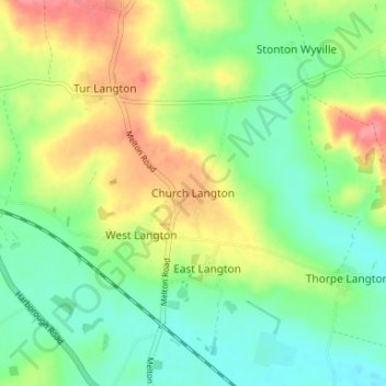
Name: Church Langton topographic map, elevation, terrain.
Average elevation: 328 ft
Minimum elevation: 226 ft
Maximum elevation: 486 ft
Make a donation
Gear up for your next adventure:
As an Amazon Associate, this site earns from qualifying purchases at no extra cost to you.
Other topographic maps
Click on a map to view its topography, its elevation and its terrain.
Burton Overy
United Kingdom > England > Leicestershire > Harborough > Burton Overy
Average elevation: 413 ft
Make a donation
Gear up for your next adventure:
As an Amazon Associate, this site earns from qualifying purchases at no extra cost to you.
Adrian's Spinney
United Kingdom > England > Leicestershire > Harborough > Stoughton
Average elevation: 371 ft
Stoughton
United Kingdom > England > Leicestershire > Harborough > Stoughton
Average elevation: 400 ft
Make a donation
Gear up for your next adventure:
As an Amazon Associate, this site earns from qualifying purchases at no extra cost to you.
Illston on the Hill
United Kingdom > England > Leicestershire > Harborough > Illston on the Hill
Average elevation: 518 ft
Gilmorton
United Kingdom > England > Leicestershire > Harborough > Gilmorton
Average elevation: 446 ft
Great Glen
United Kingdom > England > Leicestershire > Harborough > Great Glen
Average elevation: 377 ft
Make a donation
Gear up for your next adventure:
As an Amazon Associate, this site earns from qualifying purchases at no extra cost to you.
South Kilworth
United Kingdom > England > Leicestershire > Harborough > South Kilworth
Average elevation: 440 ft
Broughton Astley
United Kingdom > England > Leicestershire > Harborough > Broughton Astley
Average elevation: 285 ft
Make a donation
Gear up for your next adventure:
As an Amazon Associate, this site earns from qualifying purchases at no extra cost to you.
Make a donation
Gear up for your next adventure:
As an Amazon Associate, this site earns from qualifying purchases at no extra cost to you.
Kimcote and Walton
United Kingdom > England > Leicestershire > Harborough > Kimcote and Walton
Average elevation: 472 ft
Saddington
United Kingdom > England > Leicestershire > Harborough > Saddington
Average elevation: 417 ft
Make a donation
Gear up for your next adventure:
As an Amazon Associate, this site earns from qualifying purchases at no extra cost to you.
Little Stretton
United Kingdom > England > Leicestershire > Harborough > Little Stretton
Average elevation: 433 ft
Make a donation
Gear up for your next adventure:
As an Amazon Associate, this site earns from qualifying purchases at no extra cost to you.
Claybrooke Magna
United Kingdom > England > Leicestershire > Harborough > Claybrooke Magna
Average elevation: 335 ft
Make a donation
Gear up for your next adventure:
As an Amazon Associate, this site earns from qualifying purchases at no extra cost to you.
Stonton Wyville
United Kingdom > England > Leicestershire > Harborough > Stonton Wyville
Average elevation: 371 ft
Make a donation
Gear up for your next adventure:
As an Amazon Associate, this site earns from qualifying purchases at no extra cost to you.
Saddington Reservoir
United Kingdom > England > Leicestershire > Harborough > Saddington
Average elevation: 420 ft
Make a donation
Gear up for your next adventure:
As an Amazon Associate, this site earns from qualifying purchases at no extra cost to you.
Smeeton Westerby
United Kingdom > England > Leicestershire > Harborough > Smeeton Westerby
Average elevation: 367 ft
Bruntingthorpe
United Kingdom > England > Leicestershire > Harborough > Bruntingthorpe
Average elevation: 433 ft
Dunton Bassett
United Kingdom > England > Leicestershire > Harborough > Dunton Bassett
Average elevation: 377 ft
Make a donation
Gear up for your next adventure:
As an Amazon Associate, this site earns from qualifying purchases at no extra cost to you.
Make a donation
Gear up for your next adventure:
As an Amazon Associate, this site earns from qualifying purchases at no extra cost to you.
Husbands Bosworth
United Kingdom > England > Leicestershire > Harborough > Husbands Bosworth
Average elevation: 466 ft
Scraptoft
United Kingdom > England > Leicestershire > Harborough > Scraptoft
Average elevation: 361 ft
Make a donation
Gear up for your next adventure:
As an Amazon Associate, this site earns from qualifying purchases at no extra cost to you.