Geolocate

Skeffington topographic map

Click on the map to display elevation.

About this map

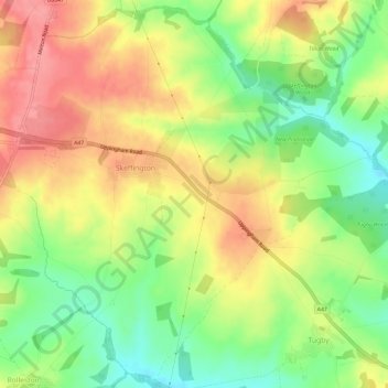
Name: Skeffington topographic map, elevation, terrain.

Location: Skeffington, Harborough, Leicestershire, England, United Kingdom (52.59672 -0.92459 52.63132 -0.86564)

Average elevation: 577 ft

Minimum elevation: 423 ft

Maximum elevation: 725 ft

Other topographic maps

Click on a map to view its topography, its elevation and its terrain.

Tugby

United Kingdom > England > Leicestershire > Harborough

Average elevation: 518 ft

Shangton

United Kingdom > England > Leicestershire > Harborough

Average elevation: 417 ft

Saddington

United Kingdom > England > Leicestershire > Harborough

Average elevation: 413 ft

Tur Langton

United Kingdom > England > Leicestershire > Harborough

Average elevation: 371 ft

Goadby

United Kingdom > England > Leicestershire > Harborough

Average elevation: 486 ft

Burton Overy

United Kingdom > England > Leicestershire > Harborough

Average elevation: 427 ft

Rolleston

United Kingdom > England > Leicestershire > Harborough

Average elevation: 545 ft

Gilmorton

United Kingdom > England > Leicestershire > Harborough

Average elevation: 446 ft

Drayton

United Kingdom > England > Leicestershire > Harborough

Average elevation: 269 ft

Scraptoft

United Kingdom > England > Leicestershire > Harborough

Average elevation: 338 ft

Ashby Parva

United Kingdom > England > Leicestershire > Harborough

Average elevation: 413 ft

Foxton

United Kingdom > England > Leicestershire > Harborough

Average elevation: 351 ft

Bitteswell

United Kingdom > England > Leicestershire > Harborough

Average elevation: 420 ft

Mowsley

United Kingdom > England > Leicestershire > Harborough

Average elevation: 482 ft

Thurnby

United Kingdom > England > Leicestershire > Harborough

Average elevation: 358 ft

Shawell

United Kingdom > England > Leicestershire > Harborough > Shawell

Average elevation: 410 ft

Hungarton

United Kingdom > England > Leicestershire > Harborough > Hungarton

Average elevation: 427 ft

Foxton Locks

United Kingdom > England > Leicestershire > Harborough > Gumley

Average elevation: 394 ft

Bringhurst

United Kingdom > England > Leicestershire > Harborough

Average elevation: 243 ft

Glooston

United Kingdom > England > Leicestershire > Harborough > Glooston

Average elevation: 384 ft

Horninghold

United Kingdom > England > Leicestershire > Harborough

Average elevation: 407 ft

Bushby

United Kingdom > England > Leicestershire > Harborough

Average elevation: 371 ft

Gear up for your next adventure:

🪶LED Camping Lantern - Bright lantern for camp lighting
🦶Carbon Trekking Poles - Reduce knee impact on steep descents with ultra-light poles
🥩Freeze-Dried Meals - Nutritious and lightweight food for remote expeditions
📷Action Camera - Capture your outdoor adventures in HD
👟Trail Running Shoes - Lightweight shoes for trail runners

As an Amazon Associate, this site earns from qualifying purchases at no extra cost to you.