Geolocate

Gilmorton topographic map

Click on the map to display elevation.

About this map

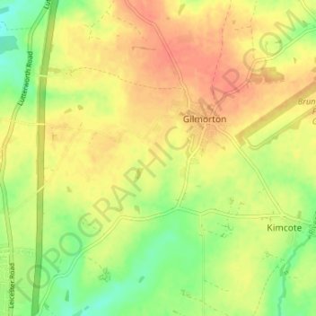
Name: Gilmorton topographic map, elevation, terrain.

Location: Gilmorton, Harborough, Leicestershire, England, United Kingdom (52.46565 -1.19853 52.49676 -1.13339)

Average elevation: 446 ft

Minimum elevation: 358 ft

Maximum elevation: 512 ft

Other topographic maps

Click on a map to view its topography, its elevation and its terrain.

Fleckney

United Kingdom > England > Leicestershire > Harborough

Average elevation: 397 ft

Hallaton

United Kingdom > England > Leicestershire > Harborough > Hallaton

Average elevation: 410 ft

Owston

United Kingdom > England > Leicestershire > Harborough

Average elevation: 554 ft

Tugby

United Kingdom > England > Leicestershire > Harborough

Average elevation: 518 ft

Shangton

United Kingdom > England > Leicestershire > Harborough

Average elevation: 417 ft

Catthorpe

United Kingdom > England > Leicestershire > Harborough

Average elevation: 381 ft

Horninghold

United Kingdom > England > Leicestershire > Harborough

Average elevation: 423 ft

Stoughton

United Kingdom > England > Leicestershire > Harborough > Stoughton

Average elevation: 400 ft

Billesdon

United Kingdom > England > Leicestershire > Harborough

Average elevation: 587 ft

Marefield

United Kingdom > England > Leicestershire > Harborough

Average elevation: 463 ft

Gilmorton

United Kingdom > England > Leicestershire > Harborough > Gilmorton

Average elevation: 446 ft

Slawston

United Kingdom > England > Leicestershire > Harborough > Slawston

Average elevation: 308 ft

Lutterworth

United Kingdom > England > Leicestershire > Harborough

Average elevation: 410 ft

Glooston

United Kingdom > England > Leicestershire > Harborough > Glooston

Average elevation: 384 ft

Mowsley

United Kingdom > England > Leicestershire > Harborough

Average elevation: 482 ft

Shawell

United Kingdom > England > Leicestershire > Harborough

Average elevation: 417 ft

Saddington

United Kingdom > England > Leicestershire > Harborough

Average elevation: 413 ft

Tur Langton

United Kingdom > England > Leicestershire > Harborough

Average elevation: 371 ft

Goadby

United Kingdom > England > Leicestershire > Harborough

Average elevation: 486 ft

Burton Overy

United Kingdom > England > Leicestershire > Harborough

Average elevation: 427 ft

Rolleston

United Kingdom > England > Leicestershire > Harborough

Average elevation: 545 ft

Drayton

United Kingdom > England > Leicestershire > Harborough

Average elevation: 269 ft

Scraptoft

United Kingdom > England > Leicestershire > Harborough

Average elevation: 338 ft

Foxton

United Kingdom > England > Leicestershire > Harborough

Average elevation: 351 ft

Nevill Holt

United Kingdom > England > Leicestershire > Harborough

Average elevation: 377 ft

Gumley

United Kingdom > England > Leicestershire > Harborough

Average elevation: 427 ft

Foxton

United Kingdom > England > Leicestershire > Harborough

Average elevation: 335 ft

Glooston

United Kingdom > England > Leicestershire > Harborough

Average elevation: 394 ft

Shearsby

United Kingdom > England > Leicestershire > Harborough > Shearsby

Average elevation: 430 ft

Walcote

United Kingdom > England > Leicestershire > Harborough

Average elevation: 433 ft

Bitteswell

United Kingdom > England > Leicestershire > Harborough

Average elevation: 420 ft

Skeffington

United Kingdom > England > Leicestershire > Harborough

Average elevation: 577 ft

Allexton

United Kingdom > England > Leicestershire > Harborough

Average elevation: 397 ft

Launde

United Kingdom > England > Leicestershire > Harborough

Average elevation: 541 ft

Gaulby

United Kingdom > England > Leicestershire > Harborough > Gaulby

Average elevation: 509 ft

Goadby

United Kingdom > England > Leicestershire > Harborough

Average elevation: 482 ft

Great Easton

United Kingdom > England > Leicestershire > Harborough

Average elevation: 295 ft

Blaston

United Kingdom > England > Leicestershire > Harborough > Blaston

Average elevation: 364 ft

Keyham

United Kingdom > England > Leicestershire > Harborough > Keyham

Average elevation: 400 ft

Cotesbach

United Kingdom > England > Leicestershire > Harborough

Average elevation: 397 ft

Medbourne

United Kingdom > England > Leicestershire > Harborough

Average elevation: 299 ft

Lubenham

United Kingdom > England > Leicestershire > Harborough

Average elevation: 361 ft

Stockerston

United Kingdom > England > Leicestershire > Harborough

Average elevation: 384 ft

Thurnby

United Kingdom > England > Leicestershire > Harborough

Average elevation: 358 ft

Shawell

United Kingdom > England > Leicestershire > Harborough > Shawell

Average elevation: 410 ft

Hungarton

United Kingdom > England > Leicestershire > Harborough > Hungarton

Average elevation: 427 ft

Bringhurst

United Kingdom > England > Leicestershire > Harborough

Average elevation: 243 ft

Horninghold

United Kingdom > England > Leicestershire > Harborough

Average elevation: 407 ft

Bushby

United Kingdom > England > Leicestershire > Harborough

Average elevation: 371 ft

Swinford

United Kingdom > England > Leicestershire > Harborough > Swinford

Average elevation: 407 ft

Foxton Locks

United Kingdom > England > Leicestershire > Harborough > Gumley

Average elevation: 394 ft

Scraptoft

United Kingdom > England > Leicestershire > Harborough > Scraptoft

Average elevation: 361 ft

Walcote

United Kingdom > England > Leicestershire > Harborough

Average elevation: 433 ft

Lutterworth

United Kingdom > England > Leicestershire > Harborough

Average elevation: 410 ft

Gear up for your next adventure:

🔋Solar Power Banks - Keep your GPS and phone charged in remote wilderness areas
🔊Portable Camp Speaker - Music and alerts at camp
🛠️Outdoor Gear Repair Kit - Essential tools to fix gear on the trail
🌎3D Topographic Globes - Raised relief globes for a tactile understanding of geography
🧥Waterproof Jacket for Hiking - Breathable and rugged rain jacket for outdoor excursions

As an Amazon Associate, this site earns from qualifying purchases at no extra cost to you.