
Make a donation
Gear up for your next adventure:
As an Amazon Associate, this site earns from qualifying purchases at no extra cost to you.
Seeshaupt topographic map
Click on the map to display elevation.
Make a donation
Gear up for your next adventure:
As an Amazon Associate, this site earns from qualifying purchases at no extra cost to you.
Seeshaupt
Die Gemeinde liegt in der Region Oberland am Südende des Starnberger Sees. Das Gemeindegebiet erstreckt sich vom Seeufer nach Süden zu den Osterseen, deren nördlicher Teil ab dem Stechsee, sowie der Frechensee im Gemeindegebiet liegen. Im Westen zieht sich das Gemeindegebiet auf den Höhenrücken zwischen Starnberger und Ammersee, diese Gebiete sind dem Eberfinger Drumlinfeld zuzurechnen.
Make a donation
Gear up for your next adventure:
As an Amazon Associate, this site earns from qualifying purchases at no extra cost to you.
About this map
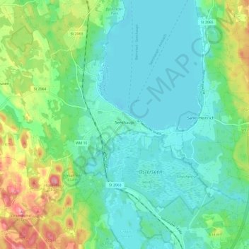
Name: Seeshaupt topographic map, elevation, terrain.
Average elevation: 2,008 ft
Minimum elevation: 1,903 ft
Maximum elevation: 2,306 ft
Make a donation
Gear up for your next adventure:
As an Amazon Associate, this site earns from qualifying purchases at no extra cost to you.
Other topographic maps
Click on a map to view its topography, its elevation and its terrain.
Make a donation
Gear up for your next adventure:
As an Amazon Associate, this site earns from qualifying purchases at no extra cost to you.
Make a donation
Gear up for your next adventure:
As an Amazon Associate, this site earns from qualifying purchases at no extra cost to you.
Make a donation
Gear up for your next adventure:
As an Amazon Associate, this site earns from qualifying purchases at no extra cost to you.
Staltannen
Deutschland > Bayern > Landkreis Weilheim-Schongau > Lauterbach
Average elevation: 2,654 ft
Grönenbach
Deutschland > Bayern > Landkreis Weilheim-Schongau > Bernbeuren
Average elevation: 2,510 ft
Fahrenberg
Deutschland > Bayern > Landkreis Weilheim-Schongau > Schwabsoien
Average elevation: 2,615 ft
Make a donation
Gear up for your next adventure:
As an Amazon Associate, this site earns from qualifying purchases at no extra cost to you.
Weilheim in Oberbayern
Deutschland > Bayern > Landkreis Weilheim-Schongau > Weilheim in Oberbayern
Average elevation: 1,916 ft
Hoher Peißenberg
Deutschland > Bayern > Landkreis Weilheim-Schongau > Hohenpeißenberg
Der Hohe Peißenberg gehört in der naturräumlichen Haupteinheitengruppe Subalpines Jungmoränenland (Nr. 03), in der Haupteinheit Ammer-Loisach-Isar-Jungmoränenland (037) und in der Untereinheit Hügel- und Moorland des Ammersees (037.0) zum Naturraum Peißenbergkämme (037.09). Seine Landschaft fällt etwa…
Average elevation: 2,657 ft
Make a donation
Gear up for your next adventure:
As an Amazon Associate, this site earns from qualifying purchases at no extra cost to you.
Lexe
Deutschland > Bayern > Landkreis Weilheim-Schongau > Peiting > Herzogsägmühle
Average elevation: 2,346 ft
Make a donation
Gear up for your next adventure:
As an Amazon Associate, this site earns from qualifying purchases at no extra cost to you.
Herzogsägmühle
Deutschland > Bayern > Landkreis Weilheim-Schongau > Peiting
Average elevation: 2,369 ft
Make a donation
Gear up for your next adventure:
As an Amazon Associate, this site earns from qualifying purchases at no extra cost to you.
Vogelfreistätte Ammersee-Südufer
Deutschland > Bayern > Landkreis Weilheim-Schongau > Aidenried
Average elevation: 1,759 ft
Make a donation
Gear up for your next adventure:
As an Amazon Associate, this site earns from qualifying purchases at no extra cost to you.
Make a donation
Gear up for your next adventure:
As an Amazon Associate, this site earns from qualifying purchases at no extra cost to you.
Rameck
Deutschland > Bayern > Landkreis Weilheim-Schongau > Huglfing > Huglfing > Rameck
Average elevation: 2,037 ft
Ficht
Deutschland > Bayern > Landkreis Weilheim-Schongau > Peißenberg > Ficht
Average elevation: 1,923 ft
Make a donation
Gear up for your next adventure:
As an Amazon Associate, this site earns from qualifying purchases at no extra cost to you.
Steinfall
Deutschland > Bayern > Landkreis Weilheim-Schongau > Hohenpeißenberg
Average elevation: 2,438 ft
Make a donation
Gear up for your next adventure:
As an Amazon Associate, this site earns from qualifying purchases at no extra cost to you.