Geolocate

Fischen topographic map

Click on the map to display elevation.

About this map

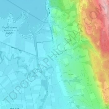
Name: Fischen topographic map, elevation, terrain.

Location: Fischen, Pähl, Landkreis Weilheim-Schongau, Bavaria, 82396, Germany (47.90849 11.13483 47.94849 11.17483)

Average elevation: 1,893 ft

Minimum elevation: 1,739 ft

Maximum elevation: 2,418 ft

Other topographic maps

Click on a map to view its topography, its elevation and its terrain.

Hohenpeißenberg

Germany > Bavaria > Landkreis Weilheim-Schongau

The climate is oceanic (Köppen: Cfb), affected by altitude and proximity to the Alps (especially in precipitation). Registering data continuously since 1781, the Hohenpeißenberg Observatory is the oldest in the world located on a mountain. The station located in the alpine foothills integrates the German…

Average elevation: 2,402 ft

Steingaden

Germany > Bavaria > Landkreis Weilheim-Schongau

Average elevation: 2,618 ft

Schongau

Germany > Bavaria > Landkreis Weilheim-Schongau

Average elevation: 2,365 ft

Schongau

Germany > Bavaria > Landkreis Weilheim-Schongau

Average elevation: 2,365 ft

Tauting

Germany > Bavaria > Landkreis Weilheim-Schongau

Average elevation: 2,133 ft

Penzberg

Germany > Bavaria > Landkreis Weilheim-Schongau

Average elevation: 1,988 ft

Raisting

Germany > Bavaria > Landkreis Weilheim-Schongau

Average elevation: 1,847 ft

Rottenbuch

Germany > Bavaria > Landkreis Weilheim-Schongau

Average elevation: 2,625 ft

Gear up for your next adventure:

🦟Ultrasonic Repellers - Create a bug-free zone at your camp or rest stop
🛡️Bear Spray Outdoor - Protection in bear country hikes
📱Heavy-Duty Phone Cases - Drop-proof and waterproof protection for outdoor navigation
🥾Men's Hiking Boots - Durable, waterproof footwear for rugged terrain and steep inclines
🎒Waterproof Dry Bags - Keep your electronics and maps dry inside your pack

As an Amazon Associate, this site earns from qualifying purchases at no extra cost to you.