
Macon topographic map
Click on the map to display elevation.
Macon
The Ocmulgee River is a major river that runs through the city. Macon is one of Georgia's three major Fall Line Cities, along with Augusta and Columbus. The Fall Line is where the hilly lands of the Piedmont plateau meet the flat terrain of the coastal plain. As such, Macon has a varied landscape of rolling hills on the north side and flat plains on the south. The fall line, where the altitude drops noticeably, causes rivers and creeks in the area to flow rapidly toward the ocean. In the past, Macon and other Fall Line cities had many textile mills powered by the rivers.
About this map
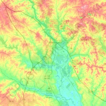
Name: Macon topographic map, elevation, terrain.
Location: Macon, Bibb County, Georgia, United States (32.66064 -83.89272 32.95287 -83.48943)
Average elevation: 417 ft
Minimum elevation: 226 ft
Maximum elevation: 689 ft
Bibb County trails, hiking, mountain biking, running and outdoor activities
Other topographic maps
Click on a map to view its topography, its elevation and its terrain.