Geolocate

Lishui topographic map

Click on the map to display elevation.

Lishui

Lishui is situated in the southwest of Zhejiang province, with its administrative area covering latitude 27° 25' to 28° 57' N and longitude 118° 41' to 120° 26' E. It borders the cities of Ningde and Nanping (Fujian province) to the southwest as well as Quzhou to the northwest, Jinhua to the north, Taizhou to the northeast, and Wenzhou to the southeast. The mountains of the area are part of the Wuyi Mountains. Elevations in the city's administration increase from northeast to southwest and there are 3,573 peaks that reach an altitude of 1,000 meters (3,300 ft) or more. The highest mountain in the province, Huangmaojian Peak, is 1,929 meters (6,329 ft) high and located near Lishui. Lishui City covers approximately 17,298 square kilometers (6,679 sq mi), of which 88.42% is mountainous. The Ou River flows through the city before emptying in the East China Sea.

Wikipedia (CC-BY-SA 3.0)

About this map

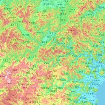
Name: Lishui topographic map, elevation, terrain.

Location: Lishui, Zhejiang, China (27.41980 118.69035 28.95323 120.43196)

Average elevation: 1,634 ft

Minimum elevation: -3 ft

Maximum elevation: 6,125 ft

Other topographic maps

Click on a map to view its topography, its elevation and its terrain.

Wuzhen

China > Zhejiang > Jiaxing

Average elevation: 13 ft

叶坑

China > Zhejiang > Longquan

Average elevation: 2,310 ft

桥西

China > Zhejiang > Longyou County > Xiaonanhai

Average elevation: 184 ft

岙滩社区

China > Zhejiang > Kaihua County > Huabu

Average elevation: 558 ft

Baoxi

China > Zhejiang > Lishui

Average elevation: 2,510 ft

Tongzhou Island

China > Zhejiang > Fuyang

Average elevation: 89 ft

Mayu

China > Zhejiang > Wenzhou

Average elevation: 148 ft

九曲坞

China > Zhejiang > Lin'an District > Tianmushan

Average elevation: 1,171 ft

Fangshan UNESCO Global Geopark

China > Zhejiang > Wenling

Average elevation: 696 ft

内黄

China > Zhejiang > Suichang County

Average elevation: 3,182 ft

Nengren

China > Zhejiang > Yueqing

Average elevation: 974 ft

河坑

China > Zhejiang > Chun'an County > Qiandaohu

Average elevation: 587 ft

Dashi Village

China > Zhejiang > Hangzhou City

Average elevation: 1,230 ft

Hengdian

China > Zhejiang > Jinhua

Average elevation: 581 ft

玉皇山

China > Zhejiang > Hangzhou City

Average elevation: 174 ft

Yunhe

China > Zhejiang

Average elevation: 1,969 ft

涧峰村

China > Zhejiang > Quzhou

Average elevation: 276 ft

杜城里

China > Zhejiang > Yuhang District > Liangzhu

Average elevation: 36 ft

Shangxi

China > Zhejiang

Average elevation: 341 ft

Lingzhi

China > Zhejiang > Shaoxing > Lingzhi

Average elevation: 23 ft

Qingbo

China > Zhejiang > Shangcheng District > Qingbo > Qingbo

Average elevation: 69 ft

Chian

China > Zhejiang > Jinhua

Average elevation: 427 ft

贴沙河

China > Zhejiang > Shangcheng District > Chaoming

Average elevation: 46 ft

Beijie

China > Zhejiang > Beijie

Average elevation: 1,322 ft

Yang Mountain

China > Zhejiang > Ningbo

Average elevation: 656 ft

Gear up for your next adventure:

🛰️Handheld GPS Units - Professional satellite navigators for precise backcountry mapping
🧭Pro Hiking Compasses - High-accuracy liquid-filled compasses for topographic orientation
🏕️Family Camping Gear - Essentials for group camping trips
🩹Survival Bandages - High‑quality bandages for emergencies
🪶Wildlife Field Guides - Learn animal tracking and species ID

As an Amazon Associate, this site earns from qualifying purchases at no extra cost to you.