Geolocate

Yunhe topographic map

Click on the map to display elevation.

About this map

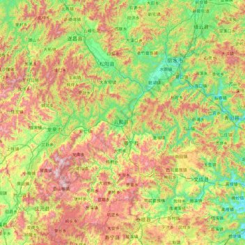
Name: Yunhe topographic map, elevation, terrain.

Location: Yunhe, Zhejiang, China (27.40961 118.87794 28.80961 120.27794)

Average elevation: 1,969 ft

Minimum elevation: 10 ft

Maximum elevation: 6,125 ft

Other topographic maps

Click on a map to view its topography, its elevation and its terrain.

Longyou County

China > Zhejiang

Average elevation: 807 ft

Hangzhou City

China > Zhejiang

Average elevation: 610 ft

Hangzhou City

China > Zhejiang

Average elevation: 610 ft

Taizhou

China > Zhejiang

Average elevation: 463 ft

Jiaxing

China > Zhejiang

Average elevation: 16 ft

Jinhua

China > Zhejiang

Average elevation: 1,037 ft

Ningbo

China > Zhejiang

Average elevation: 302 ft

Wenzhou

China > Zhejiang

Most of Wenzhou's landscape is mountainous, with many mountain tops reaching altitudes in excess of 1,000 m (3,300 ft), for example in the Yandang Mountains, a coastal mountain range dominating the eastern part of prefecture. Another dominating landscape element is the Ou River, the largest river in Wenzhou…

Average elevation: 728 ft

Haishu District

China > Zhejiang

Average elevation: 121 ft

Jiangbei District

China > Zhejiang

Average elevation: 69 ft

Haining

China > Zhejiang

Average elevation: 16 ft

Zhoushan

China > Zhejiang

Average elevation: 46 ft

Wenzhou

China > Zhejiang

Most of Wenzhou's landscape is mountainous, with many mountain tops reaching altitudes in excess of 1,000 m (3,300 ft), for example in the Yandang Mountains, a coastal mountain range dominating the eastern part of prefecture. Another dominating landscape element is the Ou River, the largest river in Wenzhou…

Average elevation: 728 ft

Yuhang District

China > Zhejiang

Average elevation: 213 ft

Jiangshan City

China > Zhejiang

Average elevation: 1,375 ft

Quzhou

China > Zhejiang

Average elevation: 1,266 ft

Dongan

China > Zhejiang > Changshan County

Average elevation: 1,142 ft

Nanji Islands

China > Zhejiang > Pingyang County

Average elevation: 26 ft

Lin'an District

China > Zhejiang

Average elevation: 696 ft

Sanmen County

China > Zhejiang

Average elevation: 528 ft

Lanxi

China > Zhejiang

Average elevation: 545 ft

Jiaxing

China > Zhejiang

Average elevation: 16 ft

Deqing County

China > Zhejiang > Huzhou

Average elevation: 200 ft

Huzhou

China > Zhejiang

Average elevation: 213 ft

Keqiao District

China > Zhejiang

Average elevation: 213 ft

Yuecheng District

China > Zhejiang

Average elevation: 148 ft

Anji County

China > Zhejiang

Anji County is located within the Yangtze Delta, where the Yangtze meets the East China Sea. The Tianmu Mountains run through southwest portion of the county, with the county's highest point, Longwang Mountain [zh], reaching 1,587.4 metres (5,208 ft) in elevation. Xitiao River, the county's longest river,…

Average elevation: 679 ft

Gongshu District

China > Zhejiang

Average elevation: 46 ft

Wenzhou

China > Zhejiang

Most of Wenzhou's landscape is mountainous, with many mountain tops reaching altitudes in excess of 1,000 m (3,300 ft), for example in the Yandang Mountains, a coastal mountain range dominating the eastern part of prefecture. Another dominating landscape element is the Ou River, the largest river in Wenzhou…

Average elevation: 712 ft

Xiaoshan District

China > Zhejiang

Topography and geomorphology

Average elevation: 249 ft

Shaoxing

China > Zhejiang

Average elevation: 591 ft

Lishui

China > Zhejiang

Lishui is situated in the southwest of Zhejiang province, with its administrative area covering latitude 27° 25' to 28° 57' N and longitude 118° 41' to 120° 26' E. It borders the cities of Ningde and Nanping (Fujian province) to the southwest as well as Quzhou to the northwest, Jinhua to the north, Taizhou…

Average elevation: 1,634 ft

Nanhu District

China > Zhejiang

Average elevation: 16 ft

Zhoushan

China > Zhejiang

Average elevation: 33 ft

Binjiang District

China > Zhejiang

Average elevation: 46 ft

Luqiao District

China > Zhejiang

Average elevation: 210 ft

Haishu District

China > Zhejiang

Average elevation: 121 ft

Maao

China > Zhejiang > Dinghai District

Average elevation: 128 ft

Gongshu District

China > Zhejiang

Average elevation: 46 ft

Xihu District

China > Zhejiang

About the formation of West Lake, there are few records in ancient documents. The "West Lake Sight-Seeing Record" (西湖游覽志) says, "West Lake is surrounded by mountains on three sides. Streams wander down the hills into the pond. There're hundreds of springs underneath. Accumulated water forms the…

Average elevation: 62 ft

Shangcheng District

China > Zhejiang

Average elevation: 66 ft

Taizhou

China > Zhejiang

Average elevation: 463 ft

Fenghua District

China > Zhejiang

Average elevation: 682 ft

Dayun

China > Zhejiang > Jiashan County > Jiaxing

Average elevation: 16 ft

Wenzhou

China > Zhejiang

Most of Wenzhou's landscape is mountainous, with many mountain tops reaching altitudes in excess of 1,000 m (3,300 ft), for example in the Yandang Mountains, a coastal mountain range dominating the eastern part of prefecture. Another dominating landscape element is the Ou River, the largest river in Wenzhou…

Average elevation: 728 ft

Gongshu District

China > Zhejiang

Average elevation: 46 ft

Lanxi

China > Zhejiang

Average elevation: 545 ft

Quzhou

China > Zhejiang

Average elevation: 1,266 ft

Pingyao

China > Zhejiang > Yuhang District

Average elevation: 157 ft

Beilun District

China > Zhejiang

Average elevation: 141 ft

Baifeng

China > Zhejiang > Beilun District

Average elevation: 187 ft

Xiaoshan District

China > Zhejiang

Topography and geomorphology

Average elevation: 249 ft

Yuyao

China > Zhejiang

Average elevation: 318 ft

Wencheng County

China > Zhejiang

Average elevation: 1,542 ft

Longquan

China > Zhejiang

Average elevation: 2,398 ft

Shangyu District

China > Zhejiang

Fuzhi mountain located in the border area of Shangyu, Shengzhou and Yuyao city. The elevation of Fuzhi mountain is 861.3 meters, cloud and mist around the mountain almost whole year, and a stone river rolling with the slope. The existence of stone river duo to the quaternary glacier movements.

Average elevation: 292 ft

Zhoushan

China > Zhejiang

Average elevation: 33 ft

Yiwu

China > Zhejiang

Average elevation: 663 ft

Hangzhou City

China > Zhejiang

Average elevation: 610 ft

Yinzhou District

China > Zhejiang

Average elevation: 213 ft

Longyou County

China > Zhejiang

Average elevation: 807 ft

Dinglan

China > Zhejiang > Shangcheng District

Average elevation: 112 ft

Gaoqiao

China > Zhejiang > Haishu District

Average elevation: 23 ft

Jinyun County

China > Zhejiang

Average elevation: 1,299 ft

Longwan District

China > Zhejiang

Average elevation: 98 ft

Guan Shan

China > Zhejiang > Daishan County

Average elevation: 52 ft

Ningbo

China > Zhejiang

Average elevation: 302 ft

Jiaojiang District

China > Zhejiang

Average elevation: 187 ft

Yuyue

China > Zhejiang > Huzhou

Average elevation: 16 ft

Linping District

China > Zhejiang

Average elevation: 33 ft

Moganshan

China > Zhejiang > Huzhou

Average elevation: 525 ft

Yiwu

China > Zhejiang

Average elevation: 663 ft

Qingyuan County

China > Zhejiang > Qingyuan

Average elevation: 2,480 ft

Tongzhou Island

China > Zhejiang > Fuyang

Average elevation: 89 ft

Qujiang District

China > Zhejiang

Average elevation: 1,106 ft

Taizhou

China > Zhejiang

Average elevation: 463 ft

Fangshan UNESCO Global Geopark

China > Zhejiang > Wenling

Average elevation: 696 ft

Qingtian County

China > Zhejiang > Lishui

Average elevation: 1,555 ft

Qiantang District

China > Zhejiang

Average elevation: 23 ft

Jindong District

China > Zhejiang

Average elevation: 535 ft

Xinan

China > Zhejiang > Kecheng District

Average elevation: 220 ft

Jiande

China > Zhejiang

Average elevation: 860 ft

Wuxing District

China > Zhejiang

Average elevation: 56 ft

Wenling

China > Zhejiang

Average elevation: 253 ft

Songyang County

China > Zhejiang > Lishui

Average elevation: 1,742 ft

Yueqing

China > Zhejiang

Average elevation: 610 ft

Hangzhou City

China > Zhejiang

Average elevation: 610 ft

Xinjie

China > Zhejiang > Xiaoshan District

Average elevation: 26 ft

Dongyang

China > Zhejiang

Dongbai Mountain (东白山)'s highest peak, Taibai Peak) is the main peak of the Kuaiji Mountains, with an altitude of 1194.6 meters. The main peak is located in Hulu Town, Dongyang City, Zhejiang Province. Since ancient times, it has been the head of the famous mountains in central Zhejiang, the "roof" of…

Average elevation: 860 ft

Tonglu County

China > Zhejiang

Average elevation: 837 ft

Taizhou

China > Zhejiang

Average elevation: 463 ft

Chengzhong

China > Zhejiang > Wucheng District

Average elevation: 157 ft

Yiwu

China > Zhejiang

Average elevation: 663 ft

Tiantai County

China > Zhejiang > Tiantai County

Average elevation: 1,142 ft

Fuyang

China > Zhejiang

Located in northwestern Zhejiang province, in 1994 Fuyang was administratively merged into Hangzhou. The city has several highways including the G320 national road, Hangxijing, as well as highways 05, 23, 19 and 14. Fuyang is 51 kilometres (32 mi) from Hangzhou and convenient transport makes it possible to…

Average elevation: 505 ft

Jiaxing

China > Zhejiang

Average elevation: 16 ft

Liucheng

China > Zhejiang > Wuyi County

Average elevation: 1,621 ft

Dongyang

China > Zhejiang

Dongbai Mountain (东白山)'s highest peak, Taibai Peak) is the main peak of the Kuaiji Mountains, with an altitude of 1194.6 meters. The main peak is located in Hulu Town, Dongyang City, Zhejiang Province. Since ancient times, it has been the head of the famous mountains in central Zhejiang, the "roof" of…

Average elevation: 860 ft

Kaihua County

China > Zhejiang > Kaihua County

Average elevation: 1,240 ft

Gear up for your next adventure:

🧴Hand Sanitizer - Keep hands clean while hiking
Solar GPS Watches - Advanced multisport watches with built-in topographic maps
💧Water Purification System - Clean water on the trail with reliable purifiers
📱Solar Portable Charger - Solar power bank for charging devices off‑grid
🚗GPS Dash Cams - Record your scenic drives through mountain passes and canyons

As an Amazon Associate, this site earns from qualifying purchases at no extra cost to you.