Geolocate

Warda topographic map

Click on the map to display elevation.

About this map

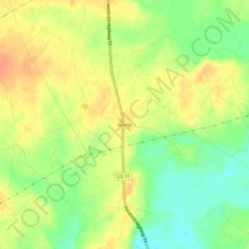
Name: Warda topographic map, elevation, terrain.

Location: Warda, Fayette County, Texas, 78960, United States (30.03522 -96.93387 30.07522 -96.89387)

Average elevation: 348 ft

Minimum elevation: 266 ft

Maximum elevation: 413 ft

Fayette County trails, hiking, mountain biking, running and outdoor activities

Other topographic maps

Click on a map to view its topography, its elevation and its terrain.

Cedar Creek Dam

United States > Texas > Fayette County > Tamberg

Average elevation: 371 ft

Round Top

United States > Texas > Fayette County

Average elevation: 390 ft

La Grange

United States > Texas > Fayette County

The center of La Grange has an elevation of 266 feet (81 m) above sea level.

Average elevation: 299 ft

Fayetteville

United States > Texas > Fayette County

Average elevation: 407 ft

Schulenburg

United States > Texas > Fayette County

Average elevation: 338 ft

La Grange

United States > Texas > Fayette County

The center of La Grange has an elevation of 266 feet (81 m) above sea level.

Average elevation: 299 ft

Gear up for your next adventure:

📶Satellite Messenger - Communication device off‑grid
🥘Titanium Cookware - Durable, featherlight pots and pans for backpacking
🔋Solar Power Banks - Keep your GPS and phone charged in remote wilderness areas
🎒Outdoor Daypacks - Lightweight backpacks designed for carrying maps and essential gear
📷Action Camera - Capture your outdoor adventures in HD

As an Amazon Associate, this site earns from qualifying purchases at no extra cost to you.