Geolocate

Fayetteville topographic map

Click on the map to display elevation.

About this map

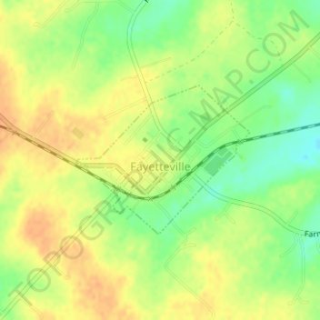
Name: Fayetteville topographic map, elevation, terrain.

Location: Fayetteville, Fayette County, Texas, United States (29.90110 -96.68807 29.91224 -96.66672)

Average elevation: 407 ft

Minimum elevation: 341 ft

Maximum elevation: 449 ft

Fayette County trails, hiking, mountain biking, running and outdoor activities

Other topographic maps

Click on a map to view its topography, its elevation and its terrain.

Muldoon

United States > Texas > Fayette County

Average elevation: 341 ft

Cedar Creek Dam

United States > Texas > Fayette County > Tamberg

Average elevation: 371 ft

Ledbetter

United States > Texas > Fayette County

Average elevation: 420 ft

Warda

United States > Texas > Fayette County

Average elevation: 348 ft

Freyburg

United States > Texas > Fayette County

Average elevation: 374 ft

Gear up for your next adventure:

🥘Titanium Cookware - Durable, featherlight pots and pans for backpacking
🔥Plasma Lighters - Windproof lighters that work in any weather condition
🧤Hiking Gloves - Protective gloves for rugged trails
🔦Compact Flashlight - Reliable flashlight for emergencies
📶Satellite Messenger - Communication device off‑grid

As an Amazon Associate, this site earns from qualifying purchases at no extra cost to you.