
Make a donation
Gear up for your next adventure:
As an Amazon Associate, this site earns from qualifying purchases at no extra cost to you.
Nickel Plate Lake topographic map
Click on the map to display elevation.
Make a donation
Gear up for your next adventure:
As an Amazon Associate, this site earns from qualifying purchases at no extra cost to you.
About this map
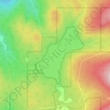
Name: Nickel Plate Lake topographic map, elevation, terrain.
Average elevation: 6,171 ft
Minimum elevation: 5,712 ft
Maximum elevation: 6,640 ft
Make a donation
Gear up for your next adventure:
As an Amazon Associate, this site earns from qualifying purchases at no extra cost to you.
Other topographic maps
Click on a map to view its topography, its elevation and its terrain.
Glacier Lake
Canada > British Columbia > Regional District of Okanagan-Similkameen > Area G (Upper Similkameen/Hedley)
Average elevation: 7,516 ft
Hedley
Canada > British Columbia > Regional District of Okanagan-Similkameen > Area G (Upper Similkameen/Hedley)
Average elevation: 2,697 ft
Hedley
Canada > British Columbia > Regional District of Okanagan-Similkameen > Area G (Upper Similkameen/Hedley)
Average elevation: 2,697 ft
Cascade Mountains
Canada > British Columbia > Regional District of Okanagan-Similkameen > Area G (Upper Similkameen/Hedley)
Average elevation: 6,493 ft
Make a donation
Gear up for your next adventure:
As an Amazon Associate, this site earns from qualifying purchases at no extra cost to you.