
Hedley topographic map
Click on the map to display elevation.
About this map
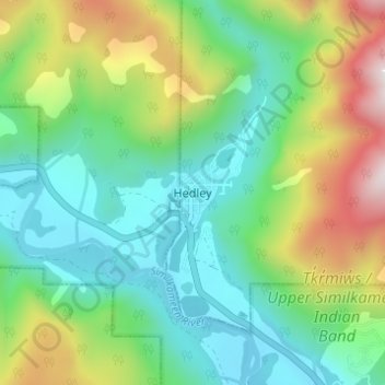
Name: Hedley topographic map, elevation, terrain.
Average elevation: 2,697 ft
Minimum elevation: 1,608 ft
Maximum elevation: 5,148 ft
Other topographic maps
Click on a map to view its topography, its elevation and its terrain.
Nickel Plate Lake
Canada > British Columbia > Regional District of Okanagan-Similkameen > Area G (Upper Similkameen/Hedley)
Average elevation: 6,171 ft
Glacier Lake
Canada > British Columbia > Regional District of Okanagan-Similkameen > Area G (Upper Similkameen/Hedley)
Average elevation: 7,516 ft
Cathedral Provincial Park
Canada > British Columbia > Regional District of Okanagan-Similkameen > Area G (Upper Similkameen/Hedley)
Average elevation: 5,945 ft