Geolocate

York topographic map

Click on the map to display elevation.

About this map

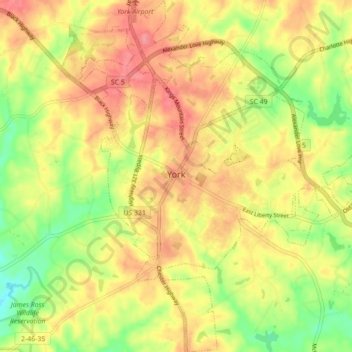
Name: York topographic map, elevation, terrain.

Location: York, York County, South Carolina, United States (34.95766 -81.27080 35.02958 -81.18506)

Average elevation: 699 ft

Minimum elevation: 558 ft

Maximum elevation: 807 ft

York County trails, hiking, mountain biking, running and outdoor activities

Other topographic maps

Click on a map to view its topography, its elevation and its terrain.

Catawba

United States > South Carolina > York County

Average elevation: 581 ft

Fort Mill

United States > South Carolina > York County > Fort Mill

Average elevation: 597 ft

Boyd Hill

United States > South Carolina > York County > Rock Hill

Average elevation: 630 ft

York

United States > South Carolina > York County > York > York

Average elevation: 643 ft

Beersheba

United States > South Carolina > York County > Beersheba

Average elevation: 653 ft

Mexico

United States > South Carolina > York County > Rock Hill

Average elevation: 627 ft

Old Farm

United States > South Carolina > York County > Rock Hill

Average elevation: 636 ft

Gear up for your next adventure:

🪑Portable Camp Table - Compact table for campsite meals
🦶Hiking Gaiters - Keep debris and water out of your boots
🕶️Glacier Sunglasses - Side shields to protect eyes from high-altitude snow glare
🛶Inflatable Kayak - Portable kayak for rivers, lakes, and expeditions
Camping Coffee Makers - Enjoy premium coffee at the summit or campsite

As an Amazon Associate, this site earns from qualifying purchases at no extra cost to you.