
Make a donation
Gear up for your next adventure:
As an Amazon Associate, this site earns from qualifying purchases at no extra cost to you.
Mahoning Township topographic map
Click on the map to display elevation.
Make a donation
Gear up for your next adventure:
As an Amazon Associate, this site earns from qualifying purchases at no extra cost to you.
About this map
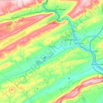
Name: Mahoning Township topographic map, elevation, terrain.
Average elevation: 883 ft
Minimum elevation: 407 ft
Maximum elevation: 1,647 ft
Carbon County trails, hiking, mountain biking, running and outdoor activities
Make a donation
Gear up for your next adventure:
As an Amazon Associate, this site earns from qualifying purchases at no extra cost to you.
Other topographic maps
Click on a map to view its topography, its elevation and its terrain.
Lake Harmony
United States > Pennsylvania > Carbon County > Kidder Township
Average elevation: 1,808 ft
Leonardsville
United States > Pennsylvania > Carbon County > Kidder Township
Average elevation: 1,660 ft
Beltzville Lake
United States > Pennsylvania > Carbon County > Towamensing Township
Average elevation: 886 ft
Make a donation
Gear up for your next adventure:
As an Amazon Associate, this site earns from qualifying purchases at no extra cost to you.
Pleasant Corners
United States > Pennsylvania > Carbon County > Mahoning Township
Average elevation: 732 ft
Christian Corner
United States > Pennsylvania > Carbon County > Lower Towamensing Township
Average elevation: 741 ft
Make a donation
Gear up for your next adventure:
As an Amazon Associate, this site earns from qualifying purchases at no extra cost to you.
Pisgah Mountain
United States > Pennsylvania > Carbon County > Summit Hill
Average elevation: 1,322 ft
White Bear Creek
United States > Pennsylvania > Carbon County > Summit Hill
Average elevation: 1,332 ft
East Jim Thorpe
United States > Pennsylvania > Carbon County > Jim Thorpe > East Jim Thorpe
Average elevation: 892 ft