
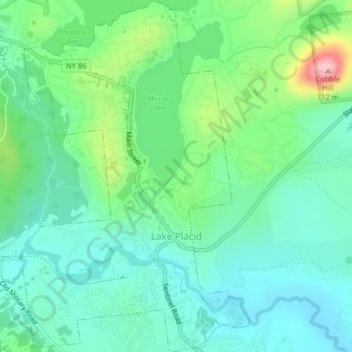
Village of Lake Placid topographic map
Interactive map
Click on the map to display elevation.
About this map
Name: Village of Lake Placid topographic map, elevation, terrain.
Average elevation: 1,831 ft
Minimum elevation: 1,663 ft
Maximum elevation: 2,300 ft
Lake Placid is well known among winter-sports enthusiasts for its skiing, both Alpine and Nordic. Whiteface Mountain (4,867 ft or 1,483 m), in nearby Wilmington about 13 miles (21 km) from Lake Placid, offers skiing, hiking, gondola rides, and mountain biking, and is the only one of the High Peaks that can be reached by an auto road. Whiteface Mountain has a vertical elevation of 3,430 feet (1,050 m), the highest vertical elevation of mountains in Eastern North America. The area has one of only 16 bobsled runs in the Western Hemisphere.
Other topographic maps
Click on a map to view its topography, its elevation and its terrain.
Heart Lake
United States > New York > Essex County
Heart Lake, Town of North Elba, Essex County, New York, United States
Average elevation: 2,264 ft
Ray Brook
United States > New York > Essex County
Ray Brook, Town of North Elba, Essex County, New York, 12977, United States
Average elevation: 1,726 ft
Grover Hills
United States > New York > Essex County > Mineville
Grover Hills, Mineville, Town of Moriah, Essex County, New York, 12956, United States
Average elevation: 1,033 ft
Keene Valley
United States > New York > Essex County > Town of Keene
Keene Valley, Town of Keene, Essex County, New York, 12943, United States
Average elevation: 1,506 ft
Town of Lewis
United States > New York > Essex County
Town of Lewis, Essex County, New York, 12950, United States
Average elevation: 1,155 ft
Saint Huberts
United States > New York > Essex County > Town of Keene
Saint Huberts, Town of Keene, Essex County, New York, 12943, United States
Average elevation: 1,759 ft
Town of Saint Armand
United States > New York > Essex County
Town of Saint Armand, Essex County, New York, 12913, United States
Average elevation: 1,893 ft
Town of Elizabethtown
United States > New York > Essex County
Town of Elizabethtown, Essex County, New York, United States
Average elevation: 1,332 ft
Witherbee
United States > New York > Essex County > Town of Moriah
Witherbee, Town of Moriah, Essex County, New York, 12998, United States
Average elevation: 1,234 ft
Craterclub
United States > New York > Essex County
Craterclub, Town of Essex, Essex County, New York, 12936, United States
Average elevation: 164 ft
Rome
United States > New York > Essex County > Town of Jay
Rome, Town of Jay, Essex County, New York, 12912, United States
Average elevation: 778 ft
Deerhead
United States > New York > Essex County > Town of Lewis
Deerhead, Town of Lewis, Essex County, New York, United States
Average elevation: 830 ft
Port Douglass
United States > New York > Essex County
Port Douglass, Town of Chesterfield, Essex County, New York, 12975, United States
Average elevation: 361 ft
Town of Essex
United States > New York > Essex County
Town of Essex, Essex County, New York, 12936, United States
Average elevation: 233 ft
Port Kent
United States > New York > Essex County
Port Kent, Town of Chesterfield, Essex County, New York, 12975, United States
Average elevation: 207 ft
Boquet
United States > New York > Essex County
Boquet, Town of Essex, Essex County, New York, 12936, United States
Average elevation: 367 ft
Whallonsburg
United States > New York > Essex County
Whallonsburg, Town of Essex, Essex County, New York, 12936, United States
Average elevation: 341 ft
Green Street
United States > New York > Essex County > Town of Jay
Green Street, Town of Jay, Essex County, New York, United States
Average elevation: 1,050 ft
Stowersville
United States > New York > Essex County > Town of Lewis
Stowersville, Town of Lewis, Essex County, New York, 12950, United States
Average elevation: 600 ft
AuSable Chasm
United States > New York > Essex County
AuSable Chasm, Town of Chesterfield, Essex County, New York, 12911, United States
Average elevation: 361 ft
Burdick Crossing
United States > New York > Essex County > Town of Crown Point
Burdick Crossing, Town of Crown Point, Essex County, New York, 12928, United States
Average elevation: 135 ft
Cold Spring Park
United States > New York > Essex County > Town of Crown Point
Cold Spring Park, Town of Crown Point, Essex County, New York, 12928, United States
Average elevation: 840 ft
Crown Point Center
United States > New York > Essex County > Town of Crown Point
Crown Point Center, Town of Crown Point, Essex County, New York, 12928, United States
Average elevation: 518 ft
Factoryville
United States > New York > Essex County > Town of Crown Point
Factoryville, Town of Crown Point, Essex County, New York, 12928, United States
Average elevation: 413 ft
Ironville
United States > New York > Essex County > Town of Crown Point
Ironville, Town of Crown Point, Essex County, New York, United States
Average elevation: 1,070 ft
Glenmore
United States > New York > Essex County > Town of Keene
Glenmore, Town of Keene, Essex County, New York, 12942, United States
Average elevation: 2,126 ft
North Jay
United States > New York > Essex County > Town of Jay
North Jay, Town of Jay, Essex County, New York, United States
Average elevation: 863 ft
Crowningshield
United States > New York > Essex County > Town of Lewis
Crowningshield, Town of Lewis, Essex County, New York, United States
Average elevation: 600 ft
Aiden Lair
United States > New York > Essex County
Aiden Lair, Town of Minerva, Essex County, New York, United States
Average elevation: 1,847 ft
Boreas River
United States > New York > Essex County
Boreas River, Essex County, New York, United States
Average elevation: 1,886 ft
The Grove
United States > New York > Essex County > Town of Jay
The Grove, Town of Jay, Essex County, New York, United States
Average elevation: 787 ft
Town of Chesterfield
United States > New York > Essex County
Town of Chesterfield, Essex County, New York, United States
Average elevation: 640 ft
Bloomingdale
United States > New York > Essex County
Bloomingdale, Town of Saint Armand, Essex County, New York, 12913, United States
Average elevation: 1,608 ft
Town of Crown Point
United States > New York > Essex County
Town of Crown Point, Essex County, New York, 12928, United States
Average elevation: 538 ft
Giant Mountain
United States > New York > Essex County > Town of Keene
Giant Mountain, Town of Keene, Essex County, New York, United States
Average elevation: 3,478 ft
Town of Westport
United States > New York > Essex County
Town of Westport, Essex County, New York, 12993, United States
Average elevation: 495 ft
Bear Mountain
United States > New York > Essex County > Town of Ticonderoga
Bear Mountain, Town of Ticonderoga, Essex County, New York, 12883, United States
Average elevation: 568 ft
Upper Jay
United States > New York > Essex County > Town of Jay
Upper Jay, Town of Jay, Essex County, New York, 12987, United States
Average elevation: 1,060 ft
Paradox
United States > New York > Essex County
Paradox, Town of Schroon, Essex County, New York, 12858, United States
Average elevation: 1,056 ft
Town of North Elba
United States > New York > Essex County
Town of North Elba, Essex County, New York, United States
Average elevation: 2,388 ft
Whiteface Mountain
United States > New York > Essex County > Town of Wilmington
Whiteface Mountain, Town of Wilmington, Essex County, New York, United States
Average elevation: 3,576 ft
Whiteface
United States > New York > Essex County
Whiteface, Town of North Elba, Essex County, New York, 12946, United States
Average elevation: 2,087 ft
Town of North Hudson
United States > New York > Essex County
Town of North Hudson, Essex County, New York, 12855, United States
Average elevation: 1,768 ft
Blue Ridge Mountain
United States > New York > Essex County > Town of North Hudson
Blue Ridge Mountain, Town of North Hudson, Essex County, New York, United States
Average elevation: 2,684 ft
Olmstedville
United States > New York > Essex County
Olmstedville, Town of Minerva, Essex County, New York, 12857, United States
Average elevation: 1,243 ft
Keeseville
United States > New York > Essex County
Keeseville, Town of Chesterfield, Essex County, New York, 12944, United States
Average elevation: 492 ft
Schroon Lake
United States > New York > Essex County > Schroon Lake
Schroon Lake, Essex County, New York, 12870, United States
Average elevation: 951 ft
Town of Moriah
United States > New York > Essex County
Town of Moriah, Essex County, New York, United States
Average elevation: 928 ft
Town of Newcomb
United States > New York > Essex County
Town of Newcomb, Essex County, New York, 12852, United States
Average elevation: 2,057 ft
Town of Minerva
United States > New York > Essex County
Town of Minerva, Essex County, New York, United States
Average elevation: 1,732 ft