
Taum Sauk Mountain topographic map
Interactive map
Click on the map to display elevation.
About this map
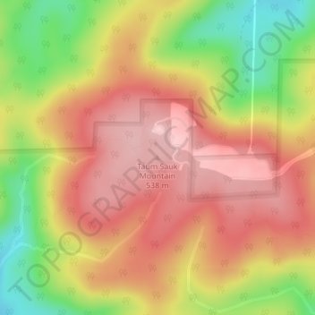
Name: Taum Sauk Mountain topographic map, elevation, terrain.
Location: Taum Sauk Mountain, Iron County, Missouri, USA (37.57028 -90.72795 37.57038 -90.72785)
Average elevation: 1,529 ft
Minimum elevation: 1,171 ft
Maximum elevation: 1,772 ft
Other topographic maps
Click on a map to view its topography, its elevation and its terrain.
Bull Shoals Lake
Bull Shoals Lake, Dixie Heights Road, Mildred, Taney County, Missouri, 65679, USA
Average elevation: 896 ft
Cuivre River
Cuivre River, Lincoln County, Missouri, 63362, USA
Average elevation: 545 ft
Lake Wappapello
USA > Missouri > Lost Creek Landing
Lake Wappapello, Pisso Point Road, Lost Creek Landing, Wayne County, Missouri, 63966, USA
Average elevation: 453 ft
Missouri Department of Conservation
Missouri Department of Conservation, Deer Park, Boone County, Missouri, USA
Average elevation: 784 ft
Cleveland Lake
Cleveland Lake, Belton, Cass County, Missouri, USA
Average elevation: 1,060 ft
Loess Bluffs National Wildlife Refuge
Loess Bluffs National Wildlife Refuge, Holt 225, Napier, Holt County, Missouri, USA
Average elevation: 896 ft
Siloam Springs
USA > Missouri > Siloam Springs
Siloam Springs, Howell County, Missouri, USA
Average elevation: 1,014 ft
Dripping Springs
USA > Missouri > Maryland Heights
Dripping Springs, Maryland Heights, Saint Louis County, Missouri, 631462, USA
Average elevation: 515 ft
Grantwood Village
USA > Missouri > Grantwood Village
Grantwood Village, Saint Louis County, Missouri, USA
Average elevation: 568 ft
Southwest Garden
USA > Missouri > Saint Louis
Southwest Garden, Saint Louis, City of Saint Louis, Missouri, USA
Average elevation: 525 ft
Point Lookout
USA > Missouri > Point Lookout
Point Lookout, Taney County, Missouri, 65726, USA
Average elevation: 863 ft
Buckner Mountain
Buckner Mountain, Madison County, Missouri, 63645, USA
Average elevation: 764 ft
Spring River
Spring River, Jasper County, Missouri, 64855, USA
Average elevation: 925 ft
Spring City
USA > Missouri > Spring City
Spring City, Newton County, Missouri, USA
Average elevation: 1,099 ft
Penrose
USA > Missouri > Saint Louis
Penrose, Saint Louis, City of Saint Louis, Missouri, 63115, USA
Average elevation: 502 ft
WHB-AM (Kansas City)
USA > Missouri > Kansas City
WHB-AM (Kansas City), North Eastern Road, Kansas City, Clay County, Missouri, 64166, USA
Average elevation: 1,024 ft
Blue Springs Lake
USA > Missouri > Rocky Mount
Blue Springs Lake, Copperas Road, Rocky Mount, Miller County, Missouri, 65026, USA
Average elevation: 833 ft
Table Rock State Park
USA > Missouri > Table Rock
Table Rock State Park, 5272, Table Rock, Taney County, Missouri, 65616, USA
Average elevation: 912 ft
Rockwoods Reservation
Rockwoods Reservation, Wildwood, Saint Louis County, Missouri, 63038, USA
Average elevation: 719 ft
Marquette Island
USA > Missouri > Cape Girardeau
Marquette Island, Cape Girardeau, Cape Girardeau County, Missouri, USA
Average elevation: 331 ft
Bennett Spring State Park
Bennett Spring State Park, 26250, Dallas County, Missouri, 65536, USA
Average elevation: 1,030 ft
Wilderness
USA > Missouri > Wilderness
Wilderness, Oregon County, Missouri, USA
Average elevation: 837 ft
Unity Lake
USA > Missouri > Kansas City
Unity Lake, Trail Ridge, Kansas City, Jackson County, Missouri, 64139, USA
Average elevation: 928 ft
Springfield Conservation Nature Center
USA > Missouri > Springfield
Springfield Conservation Nature Center, Springfield, Greene County, Missouri, 65804, USA
Average elevation: 1,220 ft
George Owens Nature Park
USA > Missouri > Independence
George Owens Nature Park, 1601, Independence, Jackson County, Missouri, 64057, USA
Average elevation: 850 ft
Franklin Island
Franklin Island, Howard County, Missouri, 65274, USA
Average elevation: 732 ft
Johnson's Shut-Ins State Park
Johnson's Shut-Ins State Park, Monterey, Reynolds County, Missouri, USA
Average elevation: 1,020 ft
Heisler Park
Heisler Park, Buckner, Jackson County, Missouri, USA
Average elevation: 751 ft
Lake Jacomo
USA > Missouri > Lee's Summit
Lake Jacomo, Rock Ledges Loop, Lee's Summit, Jackson County, Missouri, 64086, USA
Average elevation: 919 ft
Hercules Glades Wilderness Area
Hercules Glades Wilderness Area, Hercules Glades - Rock Spring Trail, Hilda, Taney County, Missouri, USA
Average elevation: 1,030 ft
Platte River
Platte River, Andrew County, Missouri, 64480, USA
Average elevation: 1,020 ft
Park Hills
USA > Missouri > Park Hills
Park Hills, St. Francois County, Missouri, 63601, USA
Average elevation: 843 ft
Runge Conservation Nature Center
USA > Missouri > Jefferson City
Runge Conservation Nature Center, Jefferson City, Cole County, Missouri, USA
Average elevation: 709 ft