Geolocate

Sigchos topographic map

Click on the map to display elevation.

About this map

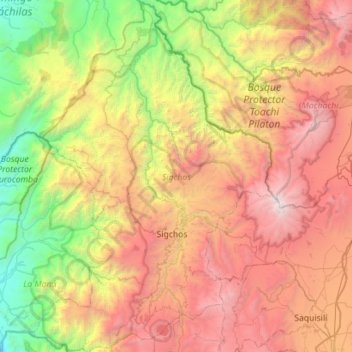
Name: Sigchos topographic map, elevation, terrain.

Location: Sigchos, Cotopaxi, Ecuador (-0.89499 -79.11735 -0.33084 -78.72068)

Average elevation: 7,979 ft

Minimum elevation: 1,243 ft

Maximum elevation: 16,975 ft

Other topographic maps

Click on a map to view its topography, its elevation and its terrain.

San Fransisco

Ecuador > Cotopaxi > Latacunga > Latacunga

Average elevation: 9,472 ft

Pillig Tapalan

Ecuador > Cotopaxi > Latacunga > Latacunga

Average elevation: 9,199 ft

Yacucocha

Ecuador > Cotopaxi > Pujilí > Zumbahua

Average elevation: 11,850 ft

Chami 2

Ecuador > Cotopaxi > Pujilí > Zumbahua

Average elevation: 11,739 ft

Loma de la Virgen

Ecuador > Cotopaxi > La Maná > La Maná

Average elevation: 1,115 ft

Laguna Quilotoa

Ecuador > Cotopaxi > Sigchos > Chugchillan

Quilotoa is a site of growing popularity. The route to the "summit" (the small town of Quilotoa) is generally traveled by hired truck or bus from the town of Zumbahua 17 kilometres (11 mi) to the South, or more commonly by bus from Latacunga. Visitors have to pay two US dollars each to enter Quilotoa. There…

Average elevation: 11,929 ft

Toachi

Ecuador > Cotopaxi > Sigchos > Chugchillan

Average elevation: 9,347 ft

Nuevo Porvenir

Ecuador > Cotopaxi > Pangua > Moraspungo

Average elevation: 863 ft

San Luis de Yacupungo

Ecuador > Cotopaxi > Latacunga > Boliche

Average elevation: 10,420 ft

Chugchilan

Ecuador > Cotopaxi > Latacunga > Latacunga

Average elevation: 9,544 ft

Quilotoa

Ecuador > Cotopaxi > Sigchos > Chugchillan

Quilotoa is a site of growing popularity. The route to the "summit" (the small town of Quilotoa) is generally traveled by hired truck or bus from the town of Zumbahua 17 kilometres (11 mi) to the South, or more commonly by bus from Latacunga. Visitors have to pay two US dollars each to enter Quilotoa. There…

Average elevation: 12,208 ft

Turuco

Ecuador > Cotopaxi > Latacunga > Tanicuchí > San Andres

Average elevation: 9,685 ft

Santa Ines

Ecuador > Cotopaxi > Latacunga > Guaytacama > Santa Ines

Average elevation: 9,593 ft

Saguambi

Ecuador > Cotopaxi > Sigchos > Saguambi

Average elevation: 6,332 ft

Gear up for your next adventure:

🥄Camping Utensil Set - Lightweight utensils for outdoor meals
🎒Gear Packing Cubes - Organize your backpack efficiently
🎒Trail Energy Bars - High‑calorie bars for hiking energy
🔥Fast-Boil Camping Stoves - Efficient cooking systems for quick trail meals
🔭Telescopic Hiking Pole - Adjustable pole for hiking stability

As an Amazon Associate, this site earns from qualifying purchases at no extra cost to you.