Geolocate

Mason topographic map

Click on the map to display elevation.

About this map

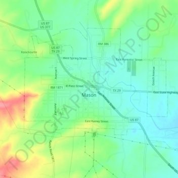
Name: Mason topographic map, elevation, terrain.

Location: Mason, Mason County, Texas, 76856, United States (30.73367 -99.25132 30.76288 -99.20185)

Average elevation: 1,588 ft

Minimum elevation: 1,490 ft

Maximum elevation: 1,785 ft

Mason County trails, hiking, mountain biking, running and outdoor activities

Other topographic maps

Click on a map to view its topography, its elevation and its terrain.

Grit

United States > Texas > Mason County

Average elevation: 1,736 ft

Streeter

United States > Texas > Mason County

Average elevation: 1,709 ft

Fredonia

United States > Texas > Mason County

Average elevation: 1,670 ft

Pontotoc

United States > Texas > Mason County

Average elevation: 1,542 ft

Gear up for your next adventure:

🧭GPS Watch Accessories - Bands and chargers for GPS watches
🛏️Cold Weather Sleeping Bag - Warm sleeping bag for cold conditions
🎒Trekking Poles - Sturdy poles for balance and stability on rough terrain
🎒Hydration Pack - Hands‑free water reservoir for long hikes
🗺️Topographic Maps - Detailed topo maps for hiking, exploring and outdoor navigation

As an Amazon Associate, this site earns from qualifying purchases at no extra cost to you.