
Dexter topographic map
Click on the map to display elevation.
About this map
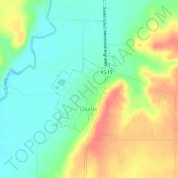
Name: Dexter topographic map, elevation, terrain.
Location: Dexter, Cowley County, Kansas, United States (37.17376 -96.72179 37.18666 -96.71046)
Average elevation: 1,227 ft
Minimum elevation: 1,145 ft
Maximum elevation: 1,345 ft
Cowley County trails, hiking, mountain biking, running and outdoor activities
Other topographic maps
Click on a map to view its topography, its elevation and its terrain.
Arkansas City
United States > Kansas > Cowley County > Arkansas City > Arkansas City
Average elevation: 1,112 ft