Geolocate

Rock topographic map

Click on the map to display elevation.

About this map

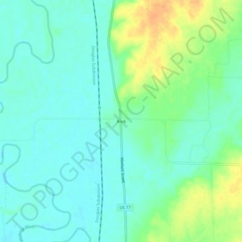
Name: Rock topographic map, elevation, terrain.

Location: Rock, Cowley County, Kansas, United States (37.42030 -97.02643 37.46030 -96.98643)

Average elevation: 1,188 ft

Minimum elevation: 1,148 ft

Maximum elevation: 1,266 ft

Cowley County trails, hiking, mountain biking, running and outdoor activities

Other topographic maps

Click on a map to view its topography, its elevation and its terrain.

Parkerfield

United States > Kansas > Cowley County

Parkerfield is located near the east edge of Arkansas City. The land topography consists of about 564 acres (261 acres platted and 302 acres (1.22 km2) unplatted at the time of incorporation) with basically a flat terrain with no natural boundaries and a drainage pattern generally to the southeast for the…

Average elevation: 1,152 ft

Dexter

United States > Kansas > Cowley County

Average elevation: 1,227 ft

Cambridge

United States > Kansas > Cowley County

Average elevation: 1,302 ft

Burden

United States > Kansas > Cowley County

Average elevation: 1,381 ft

Atlanta

United States > Kansas > Cowley County

Average elevation: 1,417 ft

Grouse Creek

United States > Kansas > Cowley County

Average elevation: 1,250 ft

Udall

United States > Kansas > Cowley County

Average elevation: 1,260 ft

Gear up for your next adventure:

🏫Relief Map Kits - Hands-on tools for teaching landforms and elevation
📦Gear Storage Bags - Organize and protect outdoor equipment
🚪Portable Camp Chair - Foldable chair for comfort at camp
🪶Survival Guide Book - Expert advice for emergency preparedness
🧭Compass with Lanyard - Easy‑carry compass for navigation

As an Amazon Associate, this site earns from qualifying purchases at no extra cost to you.