
Make a donation
Gear up for your next adventure:
As an Amazon Associate, this site earns from qualifying purchases at no extra cost to you.
Ahsahka topographic map
Click on the map to display elevation.
Make a donation
Gear up for your next adventure:
As an Amazon Associate, this site earns from qualifying purchases at no extra cost to you.
About this map
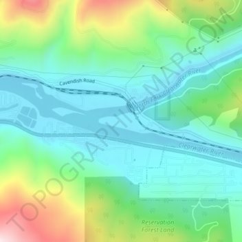
Name: Ahsahka topographic map, elevation, terrain.
Location: Ahsahka, Clearwater County, Idaho, 83520, United States (46.49212 -116.33403 46.51212 -116.31403)
Average elevation: 1,385 ft
Minimum elevation: 951 ft
Maximum elevation: 2,543 ft
Clearwater County trails, hiking, mountain biking, running and outdoor activities
Make a donation
Gear up for your next adventure:
As an Amazon Associate, this site earns from qualifying purchases at no extra cost to you.
Other topographic maps
Click on a map to view its topography, its elevation and its terrain.
Elk River
United States > Idaho > Clearwater County
Elk River is located at 46°46′58″N 116°10′48″W / 46.78278°N 116.18000°W / 46.78278; -116.18000 (46.782796, -116.180049), at an elevation of 2,854 feet (870 m) above sea level.
Average elevation: 2,976 ft