
Make a donation
Gear up for your next adventure:
As an Amazon Associate, this site earns from qualifying purchases at no extra cost to you.
Elk River topographic map
Click on the map to display elevation.
Make a donation
Gear up for your next adventure:
As an Amazon Associate, this site earns from qualifying purchases at no extra cost to you.
Elk River
Elk River is located at 46°46′58″N 116°10′48″W / 46.78278°N 116.18000°W / 46.78278; -116.18000 (46.782796, -116.180049), at an elevation of 2,854 feet (870 m) above sea level.
Make a donation
Gear up for your next adventure:
As an Amazon Associate, this site earns from qualifying purchases at no extra cost to you.
About this map
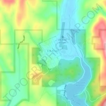
Name: Elk River topographic map, elevation, terrain.
Location: Elk River, Clearwater County, Idaho, 83827, United States (46.77864 -116.18576 46.78722 -116.17688)
Average elevation: 2,976 ft
Minimum elevation: 2,805 ft
Maximum elevation: 3,304 ft
Clearwater County trails, hiking, mountain biking, running and outdoor activities
Make a donation
Gear up for your next adventure:
As an Amazon Associate, this site earns from qualifying purchases at no extra cost to you.
Other topographic maps
Click on a map to view its topography, its elevation and its terrain.
Orofino
United States > Idaho > Clearwater County > Orofino > Orofino
The city has a climate typical of low-elevation areas in Idaho and eastern Washington. Orofino has a dry-summer continental climate (Köppen Dsb). Due to the warm summers, it nearly qualifies as a continental Mediterranean climate (Dsa). Idaho’s all-time highest temperature of 118 °F or 47.8 °C was…
Average elevation: 2,057 ft
Make a donation
Gear up for your next adventure:
As an Amazon Associate, this site earns from qualifying purchases at no extra cost to you.