
Kherson Oblast topographic map
Interactive map
Click on the map to display elevation.
About this map
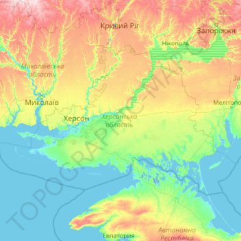
Name: Kherson Oblast topographic map, elevation, terrain.
Location: Kherson Oblast, Ukraine (45.75657 31.15910 47.60019 35.46804)
Average elevation: 151 ft
Minimum elevation: -16 ft
Maximum elevation: 860 ft
Other topographic maps
Click on a map to view its topography, its elevation and its terrain.
Dnieper River
The source of the Dnieper is the sedge bogs (Akseninsky Mokh) of the Valdai Hills in central Russia, at an elevation of 220 m (720 ft). For 115 km (71 mi) of its length, it serves as the border between Belarus and Ukraine. Its estuary, or liman, used to be defended by the strong fortress of Ochakiv.
Average elevation: 272 ft
Dnipro
The source of the Dnieper is the sedge bogs (Akseninsky Mokh) of the Valdai Hills in central Russia, at an elevation of 220 m (720 ft). For 115 km (71 mi) of its length, it serves as the border between Belarus and Ukraine. Its estuary, or liman, used to be defended by the strong fortress of Ochakiv.
Average elevation: 361 ft
Zhuravli
Ukraine > Autonomous Republic of Crimea > Євпаторійський район > Митяевское сельское поселение
Average elevation: 46 ft
Туркмен
Ukraine > Autonomous Republic of Crimea > Lenine Raion > Октябрьское сельское поселение
Average elevation: 305 ft
Vodiane
Ukraine > Dnipropetrovsk Oblast
Vodiane or Vodyane (Ukrainian: Водяне) is a village in Pokrovsk Raion, Donetsk Oblast, Ukraine. In 2001, the population was 319 and the elevation is 177m. Up until 2020, the village was part of Yasynuvata Raion, until it was merged into Pokrovsk Raion.
Average elevation: 482 ft
Dnipro
The source of the Dnieper is the sedge bogs (Akseninsky Mokh) of the Valdai Hills in central Russia, at an elevation of 220 m (720 ft). For 115 km (71 mi) of its length, it serves as the border between Belarus and Ukraine. Its estuary, or liman, used to be defended by the strong fortress of Ochakiv.
Average elevation: 361 ft
Tankovoye
Ukraine > Republic of Crimea > Bakhchysarai Raion > Куйбышевское сельское поселение
Average elevation: 554 ft
Ai-Petri
Ukraine > Autonomous Republic of Crimea > Ялтинський район > Ливадийский поселковый совет
Average elevation: 2,687 ft
Otradnoe
Ukraine > Autonomous Republic of Crimea > Ялтинський район
Vidradne is located on Crimea's southern shore at an elevation of 68 metres (223 ft). The settlement is located 9 km (5.6 mi) southeast from the town of Massandra, which it is administratively subordinate to. Its population was 582 at the 2001 Ukrainian census. Current population: 707 (2014 Census).
Average elevation: 338 ft