
Thunderbolt topographic map
Click on the map to display elevation.
About this map
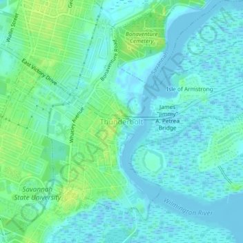
Name: Thunderbolt topographic map, elevation, terrain.
Location: Thunderbolt, Chatham County, Georgia, United States (32.02093 -81.06394 32.04606 -81.02741)
Average elevation: 16 ft
Minimum elevation: -13 ft
Maximum elevation: 46 ft
Chatham County trails, hiking, mountain biking, running and outdoor activities
Other topographic maps
Click on a map to view its topography, its elevation and its terrain.
Wilmington Island
United States > Georgia > Chatham County > Wilmington Island
Average elevation: 10 ft
Skidaway Island State Park
United States > Georgia > Chatham County > Skidaway Island
Average elevation: 16 ft
Port Wentworth Junction
United States > Georgia > Chatham County > Savannah > Port Wentworth Junction
Average elevation: 23 ft
Savannah Beach
United States > Georgia > Chatham County > Tybee Island > Savannah Beach
Average elevation: 3 ft
Tranquilla Woods
United States > Georgia > Chatham County > Savannah > Tranquilla Woods
Average elevation: 33 ft
Whitemarsh Island
United States > Georgia > Chatham County > Whitemarsh Island
Average elevation: 13 ft
Ottawa Estates
United States > Georgia > Chatham County > Bloomingdale > Ottawa Estates
Average elevation: 26 ft