
Make a donation
Gear up for your next adventure:
As an Amazon Associate, this site earns from qualifying purchases at no extra cost to you.
Annacis Island topographic map
Click on the map to display elevation.
Make a donation
Gear up for your next adventure:
As an Amazon Associate, this site earns from qualifying purchases at no extra cost to you.
About this map
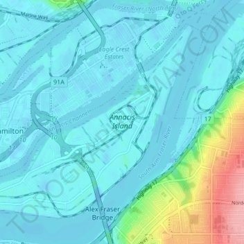
Name: Annacis Island topographic map, elevation, terrain.
Average elevation: 52 ft
Minimum elevation: -46 ft
Maximum elevation: 358 ft
Make a donation
Gear up for your next adventure:
As an Amazon Associate, this site earns from qualifying purchases at no extra cost to you.
Other topographic maps
Click on a map to view its topography, its elevation and its terrain.
Tsawwassen
Canada > British Columbia > Metro Vancouver Regional District > Delta
Average elevation: 39 ft
North Delta
Canada > British Columbia > Metro Vancouver Regional District > Delta
Average elevation: 157 ft
Make a donation
Gear up for your next adventure:
As an Amazon Associate, this site earns from qualifying purchases at no extra cost to you.
Tsawwassen Causeway Beach
Canada > British Columbia > Metro Vancouver Regional District > Delta
Average elevation: 3 ft
Tsawwassen
Canada > British Columbia > Metro Vancouver Regional District > Delta
Average elevation: 39 ft
North Delta
Canada > British Columbia > Metro Vancouver Regional District > Delta
Average elevation: 157 ft
Make a donation
Gear up for your next adventure:
As an Amazon Associate, this site earns from qualifying purchases at no extra cost to you.
Tsawwassen
Canada > British Columbia > Metro Vancouver Regional District > Delta
Average elevation: 39 ft
Burns Bog Ecological Conservancy Area
Canada > British Columbia > Metro Vancouver Regional District > Delta
Average elevation: 16 ft
Make a donation
Gear up for your next adventure:
As an Amazon Associate, this site earns from qualifying purchases at no extra cost to you.