Geolocate

Bleckede topographic map

Click on the map to display elevation.

About this map

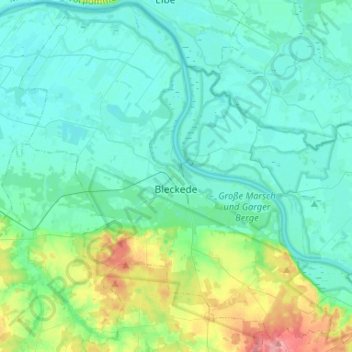
Name: Bleckede topographic map, elevation, terrain.

Location: Bleckede, Lüneburg, Lower Saxony, 21354, Germany (53.21459 10.61392 53.37066 10.86972)

Average elevation: 75 ft

Minimum elevation: 10 ft

Maximum elevation: 354 ft

Other topographic maps

Click on a map to view its topography, its elevation and its terrain.

Zeetze

Germany > Lower Saxony > Lüneburg > Amt Neuhaus

Average elevation: 43 ft

Alt Garge

Germany > Lower Saxony > Lüneburg > Bleckede

Average elevation: 79 ft

Bullendorf

Germany > Lower Saxony > Lüneburg

Average elevation: 23 ft

Stixe

Germany > Lower Saxony > Lüneburg > Amt Neuhaus

Average elevation: 46 ft

Lüneburg

Germany > Lower Saxony > Lüneburg > Lüneburg > Lüneburg

Average elevation: 105 ft

Horburg

Germany > Lower Saxony > Lüneburg

Average elevation: 16 ft

Gear up for your next adventure:

📱Solar Portable Charger - Solar power bank for charging devices off‑grid
🔭Telescopic Hiking Pole - Adjustable pole for hiking stability
🔌Solar Panel Charger - Charge gear sustainably outdoors
🥇GPS Hiking Watch - Multi‑sport GPS watch with navigation and trail tracking
👖Convertible Hiking Pants - Versatile zip-off pants for changing altitudes and temperatures

As an Amazon Associate, this site earns from qualifying purchases at no extra cost to you.