
Helotes topographic map
Click on the map to display elevation.
About this map
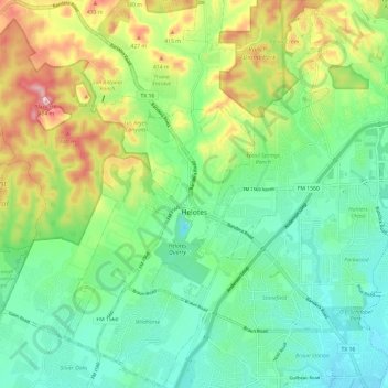
Name: Helotes topographic map, elevation, terrain.
Location: Helotes, Bexar County, Texas, 78023, United States (29.51631 -98.74399 29.62042 -98.66302)
Average elevation: 1,079 ft
Minimum elevation: 840 ft
Maximum elevation: 1,575 ft
Bexar County trails, hiking, mountain biking, running and outdoor activities
Other topographic maps
Click on a map to view its topography, its elevation and its terrain.
Medina River Natural Area
United States > Texas > Bexar County > San Antonio
Average elevation: 551 ft