
广福街道 topographic map
Interactive map
Click on the map to display elevation.
About this map
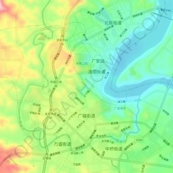
Name: 广福街道 topographic map, elevation, terrain.
Location: 广福街道, 广安区, 广安市, 四川省, 中国 (30.45384 106.59810 30.48669 106.64914)
Average elevation: 948 ft
Minimum elevation: 692 ft
Maximum elevation: 1,385 ft
广福街道东邻中桥街道办事处,南连万盛街道办事处,西接枣山镇,北靠浓洄街道办事处、协兴镇,幅员面积6.96平方公里。浅丘地形,西南高,东北低。渠江沿街道东北经鱼林社区流过,西溪河由北向南流经岩头、大寨、西溪3个村及泰和、广宁、广惠、望江、鱼林等6个社区,全民水库右干渠流经境内。气候温和,年平均气温17.8度,年降水1100毫米左右,无霜期300天左右。土壤属上沙溪庙组的灰棕紫泥土。耕地面积2067亩,人均占有耕地0.69亩。
Other topographic maps
Click on a map to view its topography, its elevation and its terrain.