
Make a donation
Gear up for your next adventure:
As an Amazon Associate, this site earns from qualifying purchases at no extra cost to you.
Aguascalientes topographic map
Click on the map to display elevation.
Make a donation
Gear up for your next adventure:
As an Amazon Associate, this site earns from qualifying purchases at no extra cost to you.
Aguascalientes
Aguascalientes (Spanish pronunciation: [ˌaɣwaskaˈljentes] ; lit. 'Hot Springs'), officially the Free and Sovereign State of Aguascalientes (Spanish: Estado Libre y Soberano de Aguascalientes), is one of the 32 states which comprise the Federal Entities of Mexico. At 22°N and with an average altitude of 1,950 m (6,400 ft) above sea level it is predominantly of semi-arid climate (Bhs and Bhk). The state is located in west-central Mexico and is located in the northern part of the Bajío region, which is in the north-central part of the country, bordered by Zacatecas to the north, east and west, and by Jalisco to the south.
Make a donation
Gear up for your next adventure:
As an Amazon Associate, this site earns from qualifying purchases at no extra cost to you.
About this map
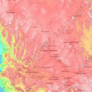
Name: Aguascalientes topographic map, elevation, terrain.
Location: Aguascalientes, Mexico (19.40000 -105.10000 24.60000 -99.90000)
Average elevation: 5,951 ft
Minimum elevation: 0 ft
Maximum elevation: 12,359 ft
Make a donation
Gear up for your next adventure:
As an Amazon Associate, this site earns from qualifying purchases at no extra cost to you.
Other topographic maps
Click on a map to view its topography, its elevation and its terrain.
Mexico City
Mexico City is situated in the Valley of Mexico, an expansive highland region characterized by a unique and varied topography. The city itself rests at an elevation of approximately 7,350 feet (2,240 meters) above sea level, surrounded by formidable mountain ranges, including the Sierra de Guadalupe to the…
Average elevation: 8,593 ft
Baja California
Baja California is the 12th-largest state by area in Mexico. Its geography ranges from beaches to forests and deserts. The backbone of the state is the Sierra de Baja California, where Picacho del Diablo, the highest point of the peninsula, is located. This mountain range effectively divides the weather…
Average elevation: 587 ft
Jalisco
Jalisco is made up of a diverse terrain that includes forests, beaches, plains, and lakes. Altitudes in the state vary from 0 to 4,300 meters (0 to 14,110 ft) above sea level, from the coast to the top of the Nevado de Colima. The Jalisco area contains all five of Mexico's natural ecosystems: arid and semi…
Average elevation: 4,268 ft
Make a donation
Gear up for your next adventure:
As an Amazon Associate, this site earns from qualifying purchases at no extra cost to you.
Baja California
Baja California is the 12th-largest state by area in Mexico. Its geography ranges from beaches to forests and deserts. The backbone of the state is the Sierra de Baja California, where Picacho del Diablo, the highest point of the peninsula, is located. This mountain range effectively divides the weather…
Average elevation: 587 ft
Monterrey
The city of Monterrey is 540 metres (1,770 ft) above sea level in the northeastern state of Nuevo León. Monterrey translated from Spanish to English is "King Mount" or "King mountain", which refers to the city's topography and the large mountains that surround it. The Santa Catarina River—dry most of the…
Average elevation: 2,825 ft
Oaxaca
The state is located in the south of Mexico, bordered by the states of Puebla, Veracruz, Chiapas and Guerrero with the Pacific Ocean to the south. It has a territory of 93,967 km2 (36,281 sq mi), accounting for less than 5% of Mexico's territory. Here several mountain chains come together, with the elevation…
Average elevation: 2,343 ft
Guadalajara
Under the Köppen climate classification, Guadalajara has a humid subtropical climate (Cwa) that is quite close to a tropical climate, featuring dry, warm winters and hot, wet summers. Guadalajara's climate is influenced by its high altitude and the general seasonality of precipitation patterns in western…
Average elevation: 5,062 ft
Make a donation
Gear up for your next adventure:
As an Amazon Associate, this site earns from qualifying purchases at no extra cost to you.
Michoacán
Much of the climate of the state is determined by altitude and other geographical features. Average temperatures vary from 13 °C (55 °F) to 29 °C (84 °F). Lower temperatures correspond with the highland areas in the north and east while the lower south and west, called La Costa (the coast) or Tierra…
Average elevation: 4,065 ft
Chiapas
The Sierra Madre de Chiapas runs parallel to the Pacific coastline of the state, northwest to southeast as a continuation of the Sierra Madre del Sur. This area has the highest altitudes in Chiapas including the Tacaná Volcano, which rises 4,093 m (13,428 ft) above sea level. Most of these mountains are…
Average elevation: 2,116 ft
Guanajuato
Guanajuato is in the center of Mexico, northwest of Mexico City, bordering Zacatecas, San Luis Potosí, Michoacán, Querétaro, and Jalisco. It is the 20th-largest of Mexico's states, with an area of 30,589 km². It has an average altitude of 2,015 meters (6,611 ft) above sea level, with its territory divided…
Average elevation: 6,578 ft
Mexico City
Mexico City (Spanish: Ciudad de México, locally [sjuˈða(ð) ðe ˈmexiko] (listen); abbr.: CDMX; Nahuatl: Altepetl Mexico) is the capital and largest city of Mexico, and the most populous city in North America. One of the world's alpha cities, it is located in the Valley of Mexico within the high Mexican…
Average elevation: 8,593 ft
Make a donation
Gear up for your next adventure:
As an Amazon Associate, this site earns from qualifying purchases at no extra cost to you.
Puebla
Most of its mountains belong to the Sierra Madre Oriental and the Trans-Mexican Volcanic Belt. The first is locally called the Sierra Norte del Puebla, entering the state from the northwest and then breaks up into the smaller chains of Sierra de Zacapoaxtla, Sierra de Huauchinango, Sierra de Teziutlán, Sierra…
Average elevation: 5,026 ft
Zacatecas
The state has an average altitude of 2230 meters above sea level, with the capital at 2,496 masl. The state has three main geographical regions, the Sierra Madre Occidental in the west, the Mexican Plateau and the Sierra Madre Oriental. Most of it is in the Sierra Madre Occidental with highly rugged peaks of…
Average elevation: 6,152 ft
Mexico City
Mexico City (Spanish: Ciudad de México, locally [sjuˈða(ð) ðe ˈmexiko] (listen); abbr.: CDMX; Nahuatl: Āltepētl Mēxihco) is the capital and largest city of Mexico, and the most populous city in North America. One of the world's alpha cities, it is located in the Valley of Mexico within the high…
Average elevation: 8,593 ft
Río Grande
Over 96% of the municipality's area lies in the drainage basin of the Aguanaval River, the main watercourse in the area which flows south to north through the municipality. This river was known as the Río Grande in the 16th and 17th centuries despite its modest size. The highest point in the municipality is…
Average elevation: 6,755 ft
Make a donation
Gear up for your next adventure:
As an Amazon Associate, this site earns from qualifying purchases at no extra cost to you.
Yucatán
The State of Yucatán is located on the Yucatán Peninsula. It borders the states of Campeche to the southwest, Quintana Roo to the east and southeast, and the Gulf of Mexico to the north and west. As a whole, the state is extremely flat with little or no topographic variation, with the exception of the Puuc…
Average elevation: 52 ft
Mérida
Mérida is located in the northwest part of the state of Yucatán, which occupies the northern portion of the Yucatán Peninsula. To the east is the state of Quintana Roo, to the west is the state of Campeche, to the north is the Gulf of Mexico, and far to the south is the state of Chiapas. The city is also…
Average elevation: 26 ft
Guerrero
The state's climate is dominated by the rainy tropical areas and rainy temperate areas. The former has high temperatures above 18 °C (64.4 °F) year round and experiences most rain in the summer and early fall. Most of this is found near the coast under 2,000 m (6,562 ft) asl. In the higher elevations away…
Average elevation: 2,828 ft
Make a donation
Gear up for your next adventure:
As an Amazon Associate, this site earns from qualifying purchases at no extra cost to you.
Jalisco
Jalisco is made up of a diverse terrain that includes forests, beaches, plains, and lakes. Altitudes in the state vary from 0 to 4,300 meters (0 to 14,110 ft) above sea level, from the coast to the top of the Nevado de Colima. The Jalisco area contains all five of Mexico's natural ecosystems: arid and semi…
Average elevation: 4,268 ft
Mexico City
Mexico City is the capital and most populous city of Mexico, as well as the most populous city in North America. It is one of the world's leading cultural and financial centers and, according to the Globalization and World Cities Research Network's 2024 ranking, is classified as an Alpha world city. Located in…
Average elevation: 8,652 ft
Make a donation
Gear up for your next adventure:
As an Amazon Associate, this site earns from qualifying purchases at no extra cost to you.
Chiapas
The Sierra Madre de Chiapas runs parallel to the Pacific coastline of the state, northwest to southeast as a continuation of the Sierra Madre del Sur. This area has the highest altitudes in Chiapas including the Tacaná Volcano, which rises 4,093 m (13,428 ft) above sea level. Most of these mountains are…
Average elevation: 2,116 ft
Make a donation
Gear up for your next adventure:
As an Amazon Associate, this site earns from qualifying purchases at no extra cost to you.
Baja California Sur
The climate of the state is dry, with an average annual temperature of 18–22 °C and average annual rainfall of less than 200mm. The lower elevations are the driest and hottest, with summer daytime temperatures above 40 °C; wintertime temperatures may fall below freezing. The exception to desert conditions…
Average elevation: 295 ft
Querétaro
Three of Mexico’s geographic zones cover parts of the state. The Mesa del Centro is in the center-west of the state, and mostly consists of small mesas with an average altitude of 2,000 meters (6,562 feet) above sea level (ASL). A few elevations reach over 3,000 meters (9,843 feet). The Sierra Madre Oriental…
Average elevation: 6,522 ft
Make a donation
Gear up for your next adventure:
As an Amazon Associate, this site earns from qualifying purchases at no extra cost to you.
Querétaro
Mexico > Querétaro > Municipio de Querétaro
The municipality has rolling hills, mountain ranges and flatlands. Most of the rolling hills cross the territory from south to north, paralleling the Querétaro-San Luis Potosí highway. Most plains are located in the north, and are of sedimentary soil with some protrusions of volcanic rock. Altitude varies…
Average elevation: 6,302 ft
Oaxaca
The state is located in the south of Mexico, bordered by the states of Puebla, Veracruz, Chiapas and Guerrero with the Pacific Ocean to the south. It has a territory of 93,967 km2 (36,281 sq mi), accounting for less than 5% of Mexico's territory. Here several mountain chains come together, with the elevation…
Average elevation: 2,343 ft
Guanajuato
Guanajuato is in the center of Mexico, northwest of Mexico City, bordering Zacatecas, San Luis Potosí, Michoacán, Querétaro, and Jalisco. It is the 20th-largest of Mexico's states, with an area of 30,589 km². It has an average altitude of 2,015 meters (6,611 ft) above sea level, with its territory divided…
Average elevation: 6,578 ft
Make a donation
Gear up for your next adventure:
As an Amazon Associate, this site earns from qualifying purchases at no extra cost to you.
Veracruz
The natural geography can be categorized into nine regions: The Sierra de Zongolica, the Tecolutla Region, the Huayacocotla Region, the Metlac River area, the Tuxtlas Region, the Central Region, the Laguna del Castillo Region, the Pueblo Viejo-Tamiahua Region and the Laguna de Alvarado Region. The topography…
Average elevation: 2,142 ft
Gómez Farías
Most of the State of Tamaulipas is semi-arid and typically covered in a thorny scrub vegetation called Tamaulipan Mezquital. Gómez Farías and a few other areas on the eastern slopes of the Sierra Madre Oriental are the exception, with high precipitation and luxuriant vegetation. El Cielo Biosphere Reserve is…
Average elevation: 1,946 ft
Make a donation
Gear up for your next adventure:
As an Amazon Associate, this site earns from qualifying purchases at no extra cost to you.
Nuevo León
Nuevo León's geography is known for englobing three of the most important physiographic provinces of the northeast region. The south end of the Great Plains is considered to start in the northernmost regions of Nuevo León. The region is characterized by the soft hills that dominates the lands neighboring the…
Average elevation: 2,641 ft
Sonora
Sonora's natural geography is divided into three parts: the Sierra Madre Occidental in the east of the state; plains and rolling hills in the center; and the coast on the Gulf of California. It is primarily arid or semiarid deserts and grasslands, with only the highest elevations having sufficient rainfall to…
Average elevation: 2,497 ft
Oaxaca
The state is in the south of Mexico, bordered by the states of Puebla, Veracruz, Chiapas and Guerrero, with the Pacific Ocean to the south. It has a territory of 93,967 km2 (36,281 sq mi), accounting for less than 5% of Mexico's territory. Here several mountain chains come together, with the elevation varying…
Average elevation: 2,343 ft
Make a donation
Gear up for your next adventure:
As an Amazon Associate, this site earns from qualifying purchases at no extra cost to you.
Yucatán
The topography of the Yucatán Peninsula is characterized by a largely flat and low-lying terrain, primarily formed from limestone and covered by a thin layer of soil. This flatness is a defining feature, as the peninsula is part of the larger Yucatán Platform, which extends across approximately 70,000 square…
Average elevation: 52 ft
Make a donation
Gear up for your next adventure:
As an Amazon Associate, this site earns from qualifying purchases at no extra cost to you.
Mérida
Mérida is located in the northwest part of the state of Yucatán, which occupies the northern portion of the Yucatán Peninsula. To the east is the state of Quintana Roo, to the west is the state of Campeche, to the north is the Gulf of Mexico, and far to the south is the state of Chiapas. The city is also…
Average elevation: 26 ft
Make a donation
Gear up for your next adventure:
As an Amazon Associate, this site earns from qualifying purchases at no extra cost to you.
Querétaro
Three of Mexico’s geographic zones cover parts of the state. The Mesa del Centro is in the center-west of the state, and mostly consists of small mesas with an average altitude of 2,000 meters (6,562 feet) above sea level (ASL). A few elevations reach over 3,000 meters (9,843 feet). The Sierra Madre Oriental…
Average elevation: 6,522 ft
Chihuahua
The main mountain range in the state is the Sierra Madre Occidental reaching a maximum altitude of 10,826 ft (3,300 m) known as Cerro Mohinora. Mountains account for one third of the state's surface area which include large coniferous forests. The climate in the mountainous regions varies. Chihuahua has more…
Average elevation: 4,583 ft
Make a donation
Gear up for your next adventure:
As an Amazon Associate, this site earns from qualifying purchases at no extra cost to you.
Mérida
The city is located near the center of the Chicxulub Crater. It has a very flat topography and is only 9 metres (30 ft) above sea level. The land outside of Mérida is covered with smaller scrub trees and former henequen fields. Almost no surface water exists, but several cenotes (sinkholes that provide access…
Average elevation: 26 ft
Tanhuato
The municipality of Tanhuato is located at an elevation between 1,600 and 2,000 metres (5,200–6,600 ft) in the Bajío region in northwestern Michoacán. It borders the Michoacanese municipalities of Yurécuaro to the east, Ecuandureo to the southeast, Ixtlán to the southwest, and Vista Hermosa to the west.…
Average elevation: 5,217 ft
Make a donation
Gear up for your next adventure:
As an Amazon Associate, this site earns from qualifying purchases at no extra cost to you.
State of Mexico
About seventy percent of the state has a temperate moist climate, which consists of the highlands of the Toluca Valley and the areas around Texcoco in the north, the Toluca Valley and the areas around Texcoco. Average year-round temperature varies between 12C and 18C with annual precipitation above 700…
Average elevation: 6,755 ft
Puebla
Most of its mountains belong to the Sierra Madre Oriental and the Trans-Mexican Volcanic Belt. The first is locally called the Sierra Norte del Puebla, entering the state from the northwest and then breaks up into the smaller chains of Sierra de Zacapoaxtla, Sierra de Huauchinango, Sierra de Teziutlán, Sierra…
Average elevation: 5,026 ft
Durango
The area of Durango is 123,451.2 km2 or 12.3 million ha; this accounts for about 6.3% of the entire territory of Mexico. It is the fourth largest state, lying at the extreme northwest of the Central Mexican Plateau, where it meets the Sierra Madre Occidental—the highest peaks in the state. The state has an…
Average elevation: 5,184 ft
Make a donation
Gear up for your next adventure:
As an Amazon Associate, this site earns from qualifying purchases at no extra cost to you.
Sinaloa
Sinaloa has a warm climate on the coast; moderately warm climate in the valleys and foothills; moderately cold in the lower mountains, and cold in the higher elevations. Its weather characteristics vary from subtropical and tropical, found on coastal plains, to cold in the nearby mountains. Temperatures range…
Average elevation: 2,457 ft
Mexico City
Mexico City (Spanish: Ciudad de México, locally [sjuˈða(ð) ðe ˈmexiko] ; abbr.: CDMX; Nahuatl: Āltepētl Mēxihco, Nahuatl pronunciation: [aːl'tepeːt͡ɬ meːˈʃiʔko]; Otomi: 'Monda) is the capital and largest city of Mexico, and the most populous city in North America. Mexico City is one of the…
Average elevation: 8,593 ft
Make a donation
Gear up for your next adventure:
As an Amazon Associate, this site earns from qualifying purchases at no extra cost to you.
Puebla
Most of the mountains of Puebla belong to the Sierra Madre Oriental and the Trans-Mexican Volcanic Belt. The first is locally called the Sierra Norte del Puebla, entering the state from the northwest and then breaks up into the smaller chains of Sierra de Zacapoaxtla, Sierra de Huauchinango, Sierra de…
Average elevation: 5,026 ft
San Luis Potosí
The mean elevation is about 6,000 ft ensuring a temperate climate for the most part. The state lies partly within the arid zone of the north, while the southern half receiving more rainfall through the influence of the Nortes, which deliver significant amounts of rain. The rainfall, however, is uncertain at…
Average elevation: 4,954 ft
Make a donation
Gear up for your next adventure:
As an Amazon Associate, this site earns from qualifying purchases at no extra cost to you.
Durango
The area of Durango is 123,451.2 km2 or 12.3 million ha; this accounts for about 6.3% of the entire territory of Mexico. It is the fourth largest state, lying at the extreme northwest of the Central Mexican Plateau, where it meets the Sierra Madre Occidental—the highest peaks in the state. The state has an…
Average elevation: 5,184 ft
Coahuila
The Sierra Madre Oriental runs northwest to southeast through the State, and the higher elevations are home to the Sierra Madre Oriental pine-oak forests. The northernmost fingers of the Sierra Madre Oriental, the Sierra del Burro and the Sierra del Carmen, reach to the border with the United States at the Rio…
Average elevation: 3,310 ft
Make a donation
Gear up for your next adventure:
As an Amazon Associate, this site earns from qualifying purchases at no extra cost to you.
Baja California
Baja California is the 12th-largest state by area in Mexico. Its geography ranges from beaches to forests and deserts. The backbone of the state is the Sierra de Baja California, where Picacho del Diablo, the highest point of the peninsula, is located. This mountain range effectively divides the weather…
Average elevation: 587 ft
Make a donation
Gear up for your next adventure:
As an Amazon Associate, this site earns from qualifying purchases at no extra cost to you.
Baja California Sur
The climate of the state is dry, with an average annual temperature of 18–22 °C and average annual rainfall of less than 200mm. The lower elevations are the driest and hottest, with summer daytime temperatures above 40 °C; wintertime temperatures may fall below freezing. The exception to desert conditions…
Average elevation: 295 ft
Make a donation
Gear up for your next adventure:
As an Amazon Associate, this site earns from qualifying purchases at no extra cost to you.
San Luis Potosí
The mean elevation is about 1,800 m (6,000 ft), ensuring a mostly temperate climate. The state lies partly within the arid zone of the north, while the southern half receiving more rainfall through the influence of the Nortes, which deliver significant amounts of rain. The rainfall, however, is uncertain at…
Average elevation: 4,954 ft
Tulum
Like most of the Yucatan Peninsula Tulum is entirely flat with a gentle slope towards the sea, so from west to east, the area never reaches an altitude higher than 25 metres (82 ft) above sea level. The municipality is 5 metres (16 ft) above sea level on average.
Average elevation: 33 ft
Make a donation
Gear up for your next adventure:
As an Amazon Associate, this site earns from qualifying purchases at no extra cost to you.
Morelos
Morelos, most of which is between 1,000 and 3,300 meters (2,900–9,800 feet) above sea level, has a very diverse topography: 42% is mountainous, 16% hilly land, and 42% flat terrain. The highest altitudes are found near the state's border with Mexico City, and the lowest are found in the Huaxtla region. The…
Average elevation: 5,387 ft
El Centenario
Mexico > Baja California Sur > Municipio de La Paz > El Centenario
Average elevation: 52 ft
Malinalco
As municipal seat, the town of Malinalco is the governing authority over 54 other named communities, which covers an area of 186.28km2. The municipality, which shares its name with the seat, has a population of 22,970 of which only 6,523 live in the town of Malinalco. It has an average elevation of 1750 meters…
Average elevation: 6,138 ft
Make a donation
Gear up for your next adventure:
As an Amazon Associate, this site earns from qualifying purchases at no extra cost to you.
Veracruz
The natural geography can be categorized into nine regions: The Sierra de Zongolica, the Tecolutla Region, the Huayacocotla Region, the Metlac River area, the Tuxtlas Region, the Central Region, the Laguna del Castillo Region, the Pueblo Viejo-Tamiahua Region and the Laguna de Alvarado Region. The topography…
Average elevation: 2,142 ft
Mexico City
Mexico City (Spanish: Ciudad de México, locally [sjuˈða(ð) ðe ˈmexiko] (listen); abbr.: CDMX; Nahuatl: Altepetl Mexico) is the capital and largest city of Mexico, and the most populous city in North America. One of the world's alpha cities, it is located in the Valley of Mexico within the high Mexican…
Average elevation: 8,593 ft
Make a donation
Gear up for your next adventure:
As an Amazon Associate, this site earns from qualifying purchases at no extra cost to you.
Aguascalientes
Aguascalientes (Spanish pronunciation: [ˌaɣwaskaˈljentes] (listen); lit. 'Hot Springs'), officially the Free and Sovereign State of Aguascalientes (Spanish: Estado Libre y Soberano de Aguascalientes), is one of the 32 states which comprise the Federal Entities of Mexico. At 22°N and with an average…
Average elevation: 6,722 ft
Cozumel
Large parts of the island are covered with mangrove forest which has many endemic animal species. Cozumel is a flat island based on limestone, resulting in a karst topography. The highest natural point on the island is less than 15 m (49 ft) above sea level. The cenotes are deep water-filled sinkholes formed…
Average elevation: 3 ft
Make a donation
Gear up for your next adventure:
As an Amazon Associate, this site earns from qualifying purchases at no extra cost to you.