
Make a donation
Gear up for your next adventure:
As an Amazon Associate, this site earns from qualifying purchases at no extra cost to you.
Albertville topographic map
Click on the map to display elevation.
Make a donation
Gear up for your next adventure:
As an Amazon Associate, this site earns from qualifying purchases at no extra cost to you.
About this map
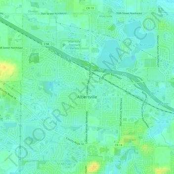
Name: Albertville topographic map, elevation, terrain.
Location: Albertville, Wright County, Minnesota, 55301, United States (45.22099 -93.68453 45.25253 -93.63198)
Average elevation: 958 ft
Minimum elevation: 935 ft
Maximum elevation: 1,010 ft
Wright County trails, hiking, mountain biking, running and outdoor activities
Make a donation
Gear up for your next adventure:
As an Amazon Associate, this site earns from qualifying purchases at no extra cost to you.
Other topographic maps
Click on a map to view its topography, its elevation and its terrain.
South Haven
United States > Minnesota > Wright County > South Haven > South Haven
Average elevation: 1,086 ft
Maple Lake
United States > Minnesota > Wright County > Maple Lake > Maple Lake
Average elevation: 1,030 ft
Make a donation
Gear up for your next adventure:
As an Amazon Associate, this site earns from qualifying purchases at no extra cost to you.
Annandale
United States > Minnesota > Wright County > Annandale > Annandale
Average elevation: 1,063 ft