
Denman Island topographic map
Click on the map to display elevation.
About this map
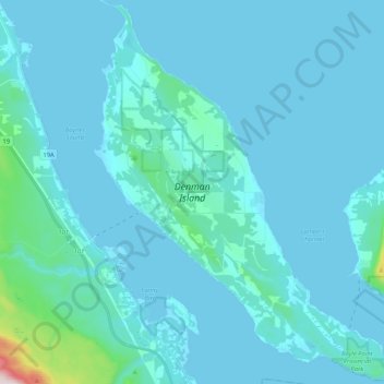
Name: Denman Island topographic map, elevation, terrain.
Average elevation: 118 ft
Minimum elevation: -3 ft
Maximum elevation: 1,906 ft
Other topographic maps
Click on a map to view its topography, its elevation and its terrain.
Fanny Bay
Canada > British Columbia > Comox Valley Regional District > Area A (Baynes Sound)
Average elevation: 118 ft
Royston
Canada > British Columbia > Comox Valley Regional District > Area A (Baynes Sound)
Average elevation: 95 ft
Union Bay
Canada > British Columbia > Comox Valley Regional District > Area A (Baynes Sound)
Average elevation: 128 ft
Buckley Bay
Canada > British Columbia > Comox Valley Regional District > Area A (Baynes Sound)
Average elevation: 115 ft
Beaufort Range
Canada > British Columbia > Comox Valley Regional District > Area A (Baynes Sound)
Average elevation: 1,427 ft
Mount Curran
Canada > British Columbia > Comox Valley Regional District > Area A (Baynes Sound)
Average elevation: 3,747 ft