Geolocate

Xenia topographic map

Click on the map to display elevation.

About this map

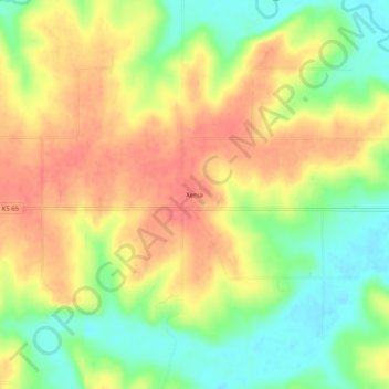
Name: Xenia topographic map, elevation, terrain.

Location: Xenia, Bourbon County, Kansas, United States (37.97531 -95.00636 38.01531 -94.96636)

Average elevation: 968 ft

Minimum elevation: 860 ft

Maximum elevation: 1,060 ft

Bourbon County trails, hiking, mountain biking, running and outdoor activities

Other topographic maps

Click on a map to view its topography, its elevation and its terrain.

Mapleton

United States > Kansas > Bourbon County

Average elevation: 876 ft

Redfield

United States > Kansas > Bourbon County

Average elevation: 863 ft

Fulton

United States > Kansas > Bourbon County

Average elevation: 827 ft

Bronson

United States > Kansas > Bourbon County

Average elevation: 1,060 ft

Gear up for your next adventure:

Backpacking Tents - Weight-optimized shelters for multi-day topographic surveys
📌Outdoor GPS Map App - Apps and devices for digital topographic navigation
❄️Traction Cleats - Prevent slips on icy trails during winter hikes
🧣Hiking Neck Gaiter - Multi‑use neck protection for outdoor weather
☀️Outdoor Sunscreen - High protection sunscreen for outdoor activities

As an Amazon Associate, this site earns from qualifying purchases at no extra cost to you.