
Shepperd topographic map
Click on the map to display elevation.
About this map
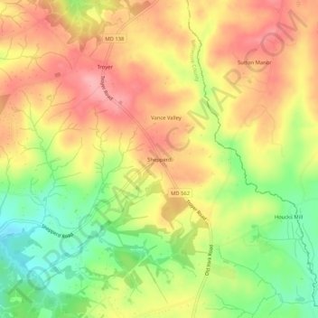
Name: Shepperd topographic map, elevation, terrain.
Location: Shepperd, Baltimore County, Maryland, 21111, United States (39.57344 -76.58913 39.61344 -76.54913)
Average elevation: 574 ft
Minimum elevation: 367 ft
Maximum elevation: 738 ft
Baltimore County trails, hiking, mountain biking, running and outdoor activities
Other topographic maps
Click on a map to view its topography, its elevation and its terrain.
Bowleys Quarters
United States > Maryland > Baltimore County > Bowleys Quarters
Average elevation: 7 ft
Soldiers Delight Natural Environment Area
United States > Maryland > Baltimore County > Owings Mills
Average elevation: 614 ft